Crucea elevation
Crucea (Suceava, Comuna Crucea), Romania elevation is 748 meters and Crucea elevation in feet is 2454 ft above sea level [src 1]. Crucea is a seat of a second-order administrative division (feature code) with elevation that is 496 meters (1627 ft) bigger than average city elevation in Romania.
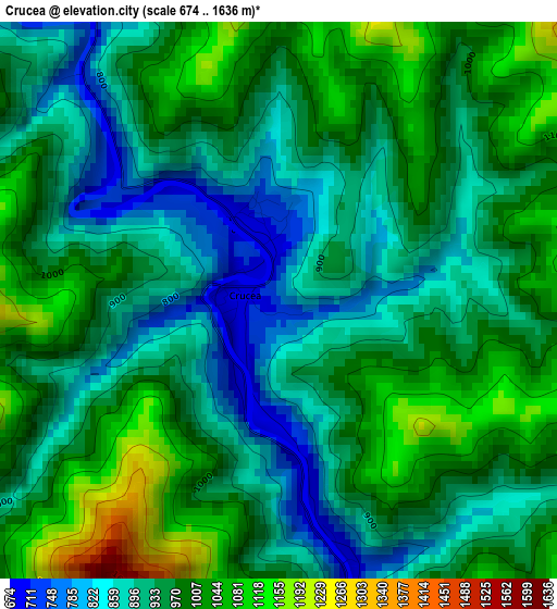
Below is the Elevation map of Crucea, which displays elevation range with different colors. Scale of the first map is from 674 to 1636 m (2211 to 5367 ft) with average elevation of 950.2 meters (=3117 ft) [note 1]
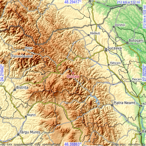
These maps also provides idea of topography and contour of this city, they are displayed at different zoom levels. More info about maps, scale and edge coordinates you can find below images.
| \ | Map #1 | Topo.Map |
| Scale [m] | 674..1636 m | × |
| Scale [ft] | 2211..5367 ft | × |
| Average | 950.2 m = 3117 ft | × |
| Width | 6.62 km = 4.1 mi | 211.9 km = 131.7 mi |
| Height | 6.62 km = 4.1 mi | 211.9 km = 131.7 mi |
| ↑Max Latitude | 47.379765° | 48.29417° |
| Latitude at center | 47.35° | 47.35° |
| ↓Min Latitude | 47.320218° | 46.38863° |
| ← Min Longitude | 25.572725° | 24.21042° |
| Longitude center | 25.61667° | 25.61667° |
| →Max Longitude | 25.660615° | 27.02292° |
Nearby cities:
Cities around Crucea sort by population:
• Câmpulung Moldovenesc elevation 655 m
20.7 km,  349°
349°
• Vatra Dornei 814 m
18.8 km,  270°
270°
• Broşteni 699 m
14.4 km,  154°
154°
• Borca 856 m
21.7 km, 148°
• Stulpicani 570 m
17.2 km,  41°
41°
• Şaru Dornei 864 m
21.4 km,  249°
249°
• Ostra 765 m
12.6 km,  63°
63°
• Sadova 788 m
22.2 km,  336°
336°
• Panaci 914 m
19.9 km,  242°
242°
• Dorna-Arini 807 m
15.8 km, 265°
• Plutonița 580 m
19.6 km, 42°
• Negrileasa 645 m
17.1 km, 61°
Multilingual:
 En español:
Crucea elevación 748 m.
 En France:
Crucea élévation 748 m.


Sources and notes:
- [note 1] Map square and city borders are not equal. Map elevation data is calculated only from area inside that square.
- [src 1] Elevation data from geonames database provided with same terms of usage.
- [src 2] The elevation map of Crucea is generated using elevation data from NASA's 3 arcsec (90m) resolution SRTM data.
- [src 3] Base (background) map © OpenStreetMap contributors tiles are generated by Geofabrik and OpenTopoMap.
Copyright & License:
This Crucea Elevation Map is licensed under CC BY-SA. You may reuse any part from this page, if you give a proper credit by linking to this URL:
 More info on terms of use page.