Câmpulung Moldovenesc elevation
Câmpulung Moldovenesc (Suceava, Municipiul Câmpulung Moldovenesc), Romania elevation is 655 meters and Câmpulung Moldovenesc elevation in feet is 2149 ft above sea level [src 1]. Câmpulung Moldovenesc is a seat of a second-order administrative division (feature code) with elevation that is 403 meters (1322 ft) bigger than average city elevation in Romania.
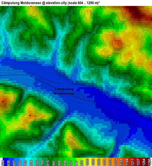
Below is the Elevation map of Câmpulung Moldovenesc, which displays elevation range with different colors. Scale of the first map is from 604 to 1290 m (1982 to 4232 ft) with average elevation of 810.7 meters (=2660 ft) [note 1]
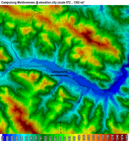
These maps also provides idea of topography and contour of this city, they are displayed at different zoom levels. More info about maps, scale and edge coordinates you can find below images.
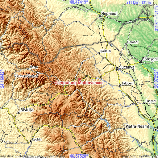
| \ | Map #1 | Map #2 | Topo.Map |
| Scale [m] | 604..1290 m | 572..1302 m | × |
| Scale [ft] | 1982..4232 ft | 1877..4272 ft | × |
| Average | 810.7 m = 2660 ft | 853.9 m = 2802 ft | × |
| Width | 6.6 km = 4.1 mi | 13.2 km = 8.2 mi | 211.1 km = 131.2 mi |
| Height | 6.6 km = 4.1 mi | 13.2 km = 8.2 mi | 211.1 km = 131.2 mi |
| ↑Max Latitude | 47.562992° | 47.592637° | 48.47419° |
| Latitude at center | 47.53333° | 47.53333° | 47.53333° |
| ↓Min Latitude | 47.503651° | 47.473956° | 46.57528° |
| ← Min Longitude | 25.522725° | 25.478779° | 24.16042° |
| Longitude center | 25.56667° | 25.56667° | 25.56667° |
| →Max Longitude | 25.610615° | 25.654561° | 26.97292° |
Nearby cities:
Cities around Câmpulung Moldovenesc sort by population:
• Frasin elevation 505 m
17.5 km,  90°
90°
• Stulpicani 570 m
16.8 km,  116°
116°
• Vama 649 m
9.5 km,  67°
67°
• Moldoviţa 696 m
16.9 km,  351°
351°
• Vatra Moldoviţei 613 m
13 km,  0°
0°
• Fundu Moldovei 850 m
12.5 km,  270°
270°
• Frumosu 711 m
11.2 km,  34°
34°
• Pojorâta 724 m
9 km,  258°
258°
• Sadova 788 m
5 km, 270°
• Plutonița 580 m
17.9 km,  109°
109°
• Strâmtura 544 m
10.1 km,  58°
58°
• Colacu 757 m
14.6 km, 272°
Multilingual:
 En español:
Câmpulung Moldovenesc elevación 655 m.
 En France:
Câmpulung Moldovenesc élévation 655 m.
 Auf Deutsch:
Câmpulung Moldovenesc höhe über dem Meeresspiegel ist 655 m.
 На русском:
Кымпулунг-Молдовенеск высота над уровнем моря 655 м
Sources and notes:
- [note 1] Map square and city borders are not equal. Map elevation data is calculated only from area inside that square.
- [src 1] Elevation data from geonames database provided with same terms of usage.
- [src 2] The elevation map of Câmpulung Moldovenesc is generated using elevation data from NASA's 3 arcsec (90m) resolution SRTM data.
- [src 3] Base (background) map © OpenStreetMap contributors tiles are generated by Geofabrik and OpenTopoMap.
Copyright & License:
This Câmpulung Moldovenesc Elevation Map is licensed under CC BY-SA. You may reuse any part from this page, if you give a proper credit by linking to this URL:
 More info on terms of use page.