Frumosu elevation
Frumosu (Suceava, Comuna Frumosu), Romania elevation is 711 meters and Frumosu elevation in feet is 2333 ft above sea level [src 1]. Frumosu is a seat of a second-order administrative division (feature code) with elevation that is 459 meters (1506 ft) bigger than average city elevation in Romania.
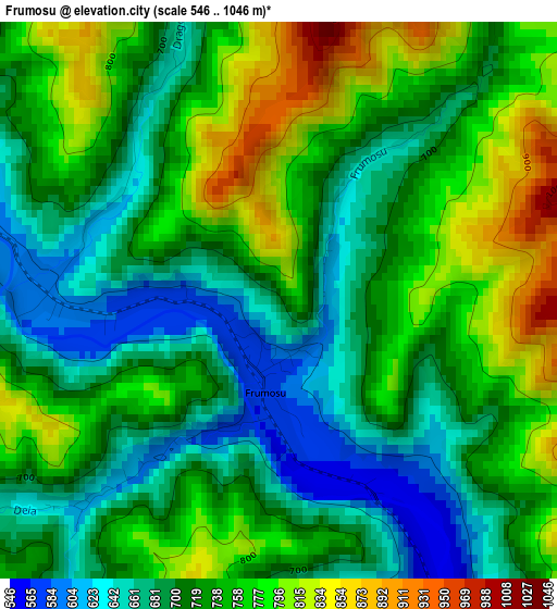
Below is the Elevation map of Frumosu, which displays elevation range with different colors. Scale of the first map is from 546 to 1046 m (1791 to 3432 ft) with average elevation of 728.2 meters (=2389 ft) [note 1]
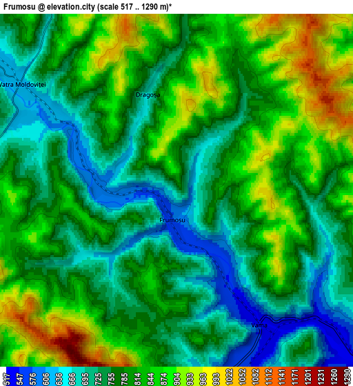
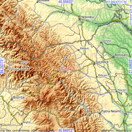
These maps also provides idea of topography and contour of this city, they are displayed at different zoom levels. More info about maps, scale and edge coordinates you can find below images.
| \ | Map #1 | Map #2 | Topo.Map |
| Scale [m] | 546..1046 m | 517..1290 m | × |
| Scale [ft] | 1791..3432 ft | 1696..4232 ft | × |
| Average | 728.2 m = 2389 ft | 791.2 m = 2596 ft | × |
| Width | 6.59 km = 4.1 mi | 13.18 km = 8.2 mi | 210.8 km = 131 mi |
| Height | 6.59 km = 4.1 mi | 13.18 km = 8.2 mi | 210.8 km = 131 mi |
| ↑Max Latitude | 47.646285° | 47.675882° | 48.55602° |
| Latitude at center | 47.61667° | 47.61667° | 47.61667° |
| ↓Min Latitude | 47.587039° | 47.55739° | 46.66013° |
| ← Min Longitude | 25.606055° | 25.562109° | 24.24375° |
| Longitude center | 25.65° | 25.65° | 25.65° |
| →Max Longitude | 25.693945° | 25.737891° | 27.05625° |
Nearby cities:
Cities around Frumosu sort by population:
• Câmpulung Moldovenesc elevation 655 m
11.2 km,  214°
214°
• Frasin 505 m
14.6 km,  129°
129°
• Vama 649 m
6.1 km,  155°
155°
• Moldoviţa 696 m
11.5 km,  310°
310°
• Vatra Moldoviţei 613 m
7.3 km,  300°
300°
• Solca 472 m
17.6 km,  58°
58°
• Mănăstirea Humorului 623 m
16.3 km,  96°
96°
• Sadova 788 m
14.6 km,  230°
230°
• Bucșoaia 505 m
14.8 km, 125°
• Plutonița 580 m
18.5 km,  144°
144°
• Strâmtura 544 m
4.6 km,  149°
149°
• Demacușa 681 m
14.1 km, 309°
Multilingual:
 En español:
Frumosu elevación 711 m.
 En France:
Frumosu élévation 711 m.


Sources and notes:
- [note 1] Map square and city borders are not equal. Map elevation data is calculated only from area inside that square.
- [src 1] Elevation data from geonames database provided with same terms of usage.
- [src 2] The elevation map of Frumosu is generated using elevation data from NASA's 3 arcsec (90m) resolution SRTM data.
- [src 3] Base (background) map © OpenStreetMap contributors tiles are generated by Geofabrik and OpenTopoMap.
Copyright & License:
This Frumosu Elevation Map is licensed under CC BY-SA. You may reuse any part from this page, if you give a proper credit by linking to this URL:
 More info on terms of use page.