Curtea de Argeş elevation
Curtea de Argeş (Arges, Municipiul Curtea de Argeș), Romania elevation is 421 meters and Curtea de Argeş elevation in feet is 1381 ft above sea level [src 1]. Curtea de Argeş is a seat of a second-order administrative division (feature code) with elevation that is 169 meters (554 ft) bigger than average city elevation in Romania.
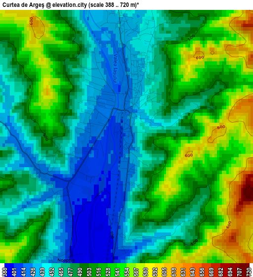
Below is the Elevation map of Curtea de Argeş, which displays elevation range with different colors. Scale of the first map is from 388 to 720 m (1273 to 2362 ft) with average elevation of 491.7 meters (=1613 ft) [note 1]
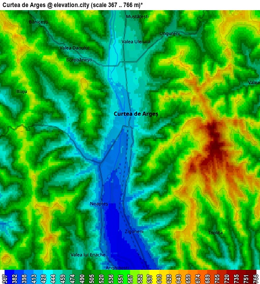
These maps also provides idea of topography and contour of this city, they are displayed at different zoom levels. More info about maps, scale and edge coordinates you can find below images.
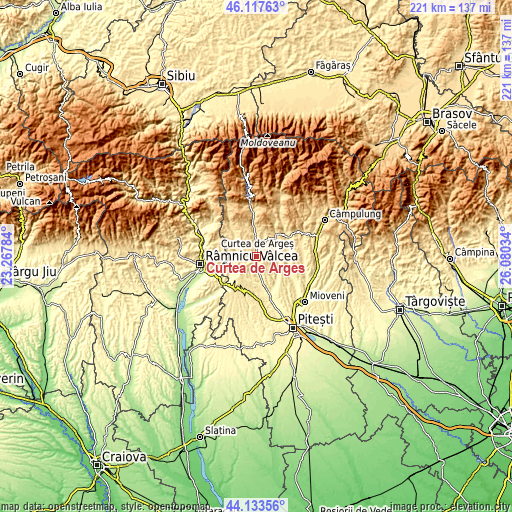
| \ | Map #1 | Map #2 | Topo.Map |
| Scale [m] | 388..720 m | 367..766 m | × |
| Scale [ft] | 1273..2362 ft | 1204..2513 ft | × |
| Average | 491.7 m = 1613 ft | 519.4 m = 1704 ft | × |
| Width | 6.89 km = 4.3 mi | 13.79 km = 8.6 mi | 220.6 km = 137.1 mi |
| Height | 6.89 km = 4.3 mi | 13.79 km = 8.6 mi | 220.6 km = 137.1 mi |
| ↑Max Latitude | 45.165213° | 45.196189° | 46.11763° |
| Latitude at center | 45.13422° | 45.13422° | 45.13422° |
| ↓Min Latitude | 45.10321° | 45.072184° | 44.13356° |
| ← Min Longitude | 24.630145° | 24.586199° | 23.26784° |
| Longitude center | 24.67409° | 24.67409° | 24.67409° |
| →Max Longitude | 24.718035° | 24.761981° | 26.08034° |
Nearby cities:
Cities around Curtea de Argeş sort by population:
• Băiculeşti elevation 413 m
7.8 km,  164°
164°
• Albeştii Pământeni 489 m
9.2 km,  356°
356°
• Mălureni 404 m
10.6 km,  111°
111°
• Tigveni 464 m
7.1 km,  269°
269°
• Valea Danului 477 m
5.8 km,  340°
340°
• Valea Iaşului 473 m
6.4 km,  31°
31°
• Albeștii Ungureni 514 m
10.1 km, 359°
• Tutana 394 m
10.3 km,  190°
190°
• Stroești 439 m
9.4 km,  93°
93°
• Toplița 506 m
6.7 km,  136°
136°
• Dobrotu 468 m
8.1 km,  351°
351°
• Albeştii de Argeş 489 m
9.2 km, 356°
Multilingual:
 En español:
Curtea de Argeş elevación 421 m.
 En France:
Curtea de Argeş élévation 421 m.
 Auf Deutsch:
Curtea de Argeş höhe über dem Meeresspiegel ist 421 m.

Sources and notes:
- [note 1] Map square and city borders are not equal. Map elevation data is calculated only from area inside that square.
- [src 1] Elevation data from geonames database provided with same terms of usage.
- [src 2] The elevation map of Curtea de Argeş is generated using elevation data from NASA's 3 arcsec (90m) resolution SRTM data.
- [src 3] Base (background) map © OpenStreetMap contributors tiles are generated by Geofabrik and OpenTopoMap.
Copyright & License:
This Curtea de Argeş Elevation Map is licensed under CC BY-SA. You may reuse any part from this page, if you give a proper credit by linking to this URL:
 More info on terms of use page.