Tigveni elevation
Tigveni (Arges, Comuna Tigveni), Romania elevation is 464 meters and Tigveni elevation in feet is 1522 ft above sea level [src 1]. Tigveni is a seat of a second-order administrative division (feature code) with elevation that is 212 meters (696 ft) bigger than average city elevation in Romania.
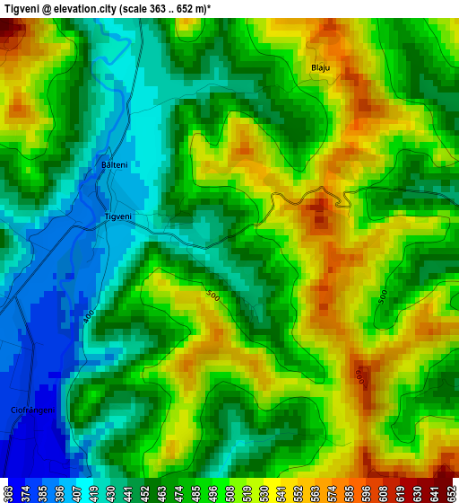
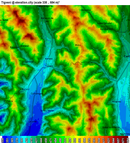
Below is the Elevation map of Tigveni, which displays elevation range with different colors. Scale of the first map is from 363 to 652 m (1191 to 2139 ft) with average elevation of 481.2 meters (=1579 ft) [note 1]
These maps also provides idea of topography and contour of this city, they are displayed at different zoom levels. More info about maps, scale and edge coordinates you can find below images.
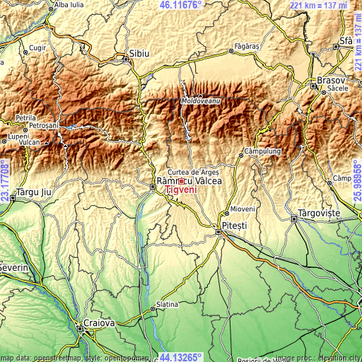
| \ | Map #1 | Map #2 | Topo.Map |
| Scale [m] | 363..652 m | 338..684 m | × |
| Scale [ft] | 1191..2139 ft | 1109..2244 ft | × |
| Average | 481.2 m = 1579 ft | 480.9 m = 1578 ft | × |
| Width | 6.89 km = 4.3 mi | 13.79 km = 8.6 mi | 220.6 km = 137.1 mi |
| Height | 6.89 km = 4.3 mi | 13.79 km = 8.6 mi | 220.6 km = 137.1 mi |
| ↑Max Latitude | 45.164323° | 45.1953° | 46.11676° |
| Latitude at center | 45.13333° | 45.13333° | 45.13333° |
| ↓Min Latitude | 45.10232° | 45.071293° | 44.13265° |
| ← Min Longitude | 24.539385° | 24.495439° | 23.17708° |
| Longitude center | 24.58333° | 24.58333° | 24.58333° |
| →Max Longitude | 24.627275° | 24.671221° | 25.98958° |
Nearby cities:
Cities around Tigveni sort by population:
• Curtea de Argeş elevation 421 m
7.1 km,  89°
89°
• Băiculeşti 413 m
11.8 km,  128°
128°
• Albeştii Pământeni 489 m
11.3 km,  35°
35°
• Valea Danului 477 m
7.6 km, 43°
• Valea Iaşului 473 m
11.8 km,  61°
61°
• Ciofrângeni 367 m
6.8 km,  215°
215°
• Tutana 394 m
11.4 km,  152°
152°
• Runcu 391 m
11.1 km,  289°
289°
• Dobrotu 468 m
10 km, 36°
• Ceparii Pământeni 535 m
9.4 km,  351°
351°
• Poienari 341 m
8.1 km,  210°
210°
• Albeştii de Argeş 489 m
11.3 km, 35°
Multilingual:
 En español:
Tigveni elevación 464 m.
 En France:
Tigveni élévation 464 m.


Sources and notes:
- [note 1] Map square and city borders are not equal. Map elevation data is calculated only from area inside that square.
- [src 1] Elevation data from geonames database provided with same terms of usage.
- [src 2] The elevation map of Tigveni is generated using elevation data from NASA's 3 arcsec (90m) resolution SRTM data.
- [src 3] Base (background) map © OpenStreetMap contributors tiles are generated by Geofabrik and OpenTopoMap.
Copyright & License:
This Tigveni Elevation Map is licensed under CC BY-SA. You may reuse any part from this page, if you give a proper credit by linking to this URL:
 More info on terms of use page.