Albeştii Pământeni elevation
Albeştii Pământeni (Arges, Comuna Albeștii de Argeș), Romania elevation is 489 meters and Albeştii Pământeni elevation in feet is 1604 ft above sea level [src 1]. Albeştii Pământeni is a populated place (feature code) with elevation that is 237 meters (778 ft) bigger than average city elevation in Romania.
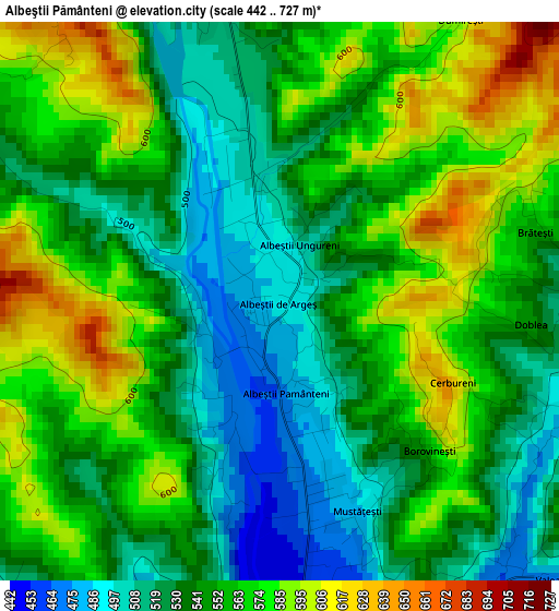
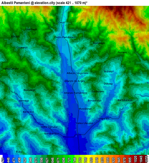
Below is the Elevation map of Albeştii Pământeni, which displays elevation range with different colors. Scale of the first map is from 442 to 727 m (1450 to 2385 ft) with average elevation of 550.4 meters (=1806 ft) [note 1]
These maps also provides idea of topography and contour of this city, they are displayed at different zoom levels. More info about maps, scale and edge coordinates you can find below images.
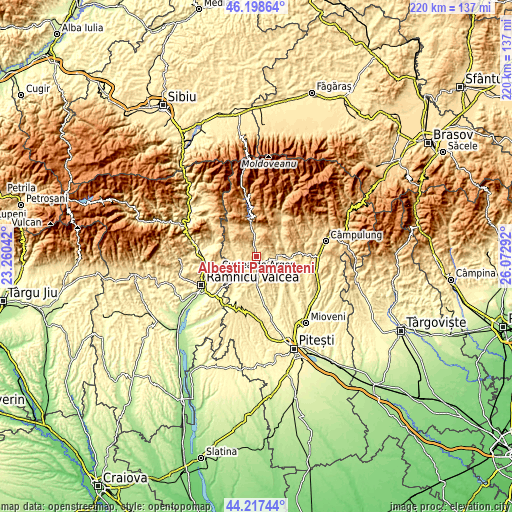
| \ | Map #1 | Map #2 | Topo.Map |
| Scale [m] | 442..727 m | 421..1070 m | × |
| Scale [ft] | 1450..2385 ft | 1381..3510 ft | × |
| Average | 550.4 m = 1806 ft | 600.2 m = 1969 ft | × |
| Width | 6.88 km = 4.3 mi | 13.77 km = 8.6 mi | 220.3 km = 136.9 mi |
| Height | 6.88 km = 4.3 mi | 13.77 km = 8.6 mi | 220.3 km = 136.9 mi |
| ↑Max Latitude | 45.247618° | 45.278549° | 46.19864° |
| Latitude at center | 45.21667° | 45.21667° | 45.21667° |
| ↓Min Latitude | 45.185705° | 45.154724° | 44.21744° |
| ← Min Longitude | 24.622725° | 24.578779° | 23.26042° |
| Longitude center | 24.66667° | 24.66667° | 24.66667° |
| →Max Longitude | 24.710615° | 24.754561° | 26.07292° |
Nearby cities:
Cities around Albeştii Pământeni sort by population:
• Curtea de Argeş elevation 421 m
9.2 km,  176°
176°
• Corbeni 620 m
9.4 km,  351°
351°
• Mușătești 495 m
8.8 km,  90°
90°
• Valea Danului 477 m
3.9 km,  199°
199°
• Valea Iaşului 473 m
5.4 km,  133°
133°
• Albeștii Ungureni 514 m
1.1 km,  25°
25°
• Oeștii Pământeni 525 m
4.1 km, 348°
• Bărăști 615 m
6.9 km,  306°
306°
• Dobrotu 468 m
1.3 km,  208°
208°
• Ceparii Pământeni 535 m
7.8 km,  270°
270°
• Cicănești 580 m
5.8 km,  304°
304°
• Albeştii de Argeş 489 m
0 km,  0°
0°
Multilingual:
 En español:
Albeştii Pământeni elevación 489 m.
 En France:
Albeştii Pământeni élévation 489 m.
 Auf Deutsch:
Albeştii Pământeni höhe über dem Meeresspiegel ist 489 m.
 На русском:
Albeştii Pământeni высота над уровнем моря 489 м
Sources and notes:
- [note 1] Map square and city borders are not equal. Map elevation data is calculated only from area inside that square.
- [src 1] Elevation data from geonames database provided with same terms of usage.
- [src 2] The elevation map of Albeştii Pământeni is generated using elevation data from NASA's 3 arcsec (90m) resolution SRTM data.
- [src 3] Base (background) map © OpenStreetMap contributors tiles are generated by Geofabrik and OpenTopoMap.
Copyright & License:
This Albeştii Pământeni Elevation Map is licensed under CC BY-SA. You may reuse any part from this page, if you give a proper credit by linking to this URL:
 More info on terms of use page.