Stroești elevation
Stroești (Arges, Comuna Mușătești), Romania elevation is 439 meters and Stroești elevation in feet is 1440 ft above sea level [src 1]. Stroești is a populated place (feature code) with elevation that is 187 meters (614 ft) bigger than average city elevation in Romania.
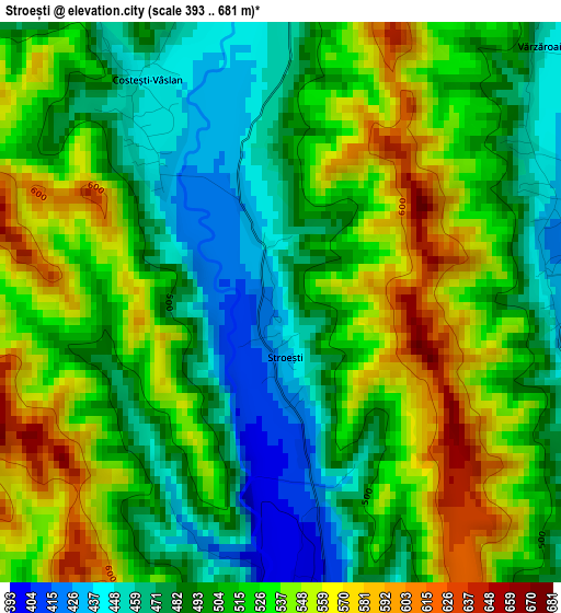
Below is the Elevation map of Stroești, which displays elevation range with different colors. Scale of the first map is from 393 to 681 m (1289 to 2234 ft) with average elevation of 512.4 meters (=1681 ft) [note 1]
These maps also provides idea of topography and contour of this city, they are displayed at different zoom levels. More info about maps, scale and edge coordinates you can find below images.
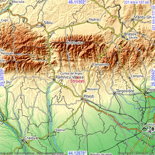
| \ | Map #1 | Topo.Map |
| Scale [m] | 393..681 m | × |
| Scale [ft] | 1289..2234 ft | × |
| Average | 512.4 m = 1681 ft | × |
| Width | 6.89 km = 4.3 mi | 220.6 km = 137.1 mi |
| Height | 6.89 km = 4.3 mi | 220.6 km = 137.1 mi |
| ↑Max Latitude | 45.160525° | 46.11302° |
| Latitude at center | 45.12953° | 45.12953° |
| ↓Min Latitude | 45.098518° | 44.12878° |
| ← Min Longitude | 24.750235° | 23.38793° |
| Longitude center | 24.79418° | 24.79418° |
| →Max Longitude | 24.838125° | 26.20043° |
Nearby cities:
Cities around Stroești sort by population:
• Curtea de Argeş elevation 421 m
9.4 km,  273°
273°
• Pietroşani 437 m
7.4 km,  36°
36°
• Coşeşti 366 m
9 km,  140°
140°
• Mălureni 404 m
3.3 km,  172°
172°
• Mușătești 495 m
9.7 km,  353°
353°
• Domneşti 496 m
8.4 km,  21°
21°
• Valea Iaşului 473 m
8.5 km,  314°
314°
• Retevoiești 426 m
3.6 km,  71°
71°
• Bădești 449 m
7 km,  48°
48°
• Jupânești 376 m
8.2 km,  147°
147°
• Toplița 506 m
6.5 km,  227°
227°
• Leicești 418 m
6.4 km,  125°
125°
Multilingual:
 En español:
Stroești elevación 439 m.
 En France:
Stroești élévation 439 m.
 Auf Deutsch:
Stroești höhe über dem Meeresspiegel ist 439 m.

Sources and notes:
- [note 1] Map square and city borders are not equal. Map elevation data is calculated only from area inside that square.
- [src 1] Elevation data from geonames database provided with same terms of usage.
- [src 2] The elevation map of Stroești is generated using elevation data from NASA's 3 arcsec (90m) resolution SRTM data.
- [src 3] Base (background) map © OpenStreetMap contributors tiles are generated by Geofabrik and OpenTopoMap.
Copyright & License:
This Stroești Elevation Map is licensed under CC BY-SA. You may reuse any part from this page, if you give a proper credit by linking to this URL:
 More info on terms of use page.