Leicești elevation
Leicești (Arges, Comuna Coşeşti), Romania elevation is 418 meters and Leicești elevation in feet is 1371 ft above sea level [src 1]. Leicești is a populated place (feature code) with elevation that is 166 meters (545 ft) bigger than average city elevation in Romania.
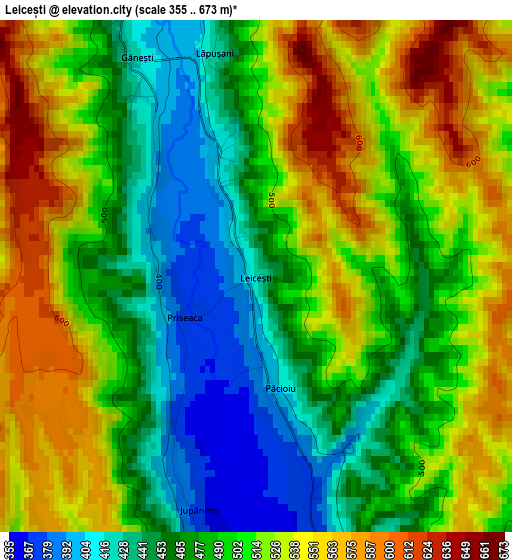
Below is the Elevation map of Leicești, which displays elevation range with different colors. Scale of the first map is from 355 to 673 m (1165 to 2208 ft) with average elevation of 499.5 meters (=1639 ft) [note 1]
These maps also provides idea of topography and contour of this city, they are displayed at different zoom levels. More info about maps, scale and edge coordinates you can find below images.
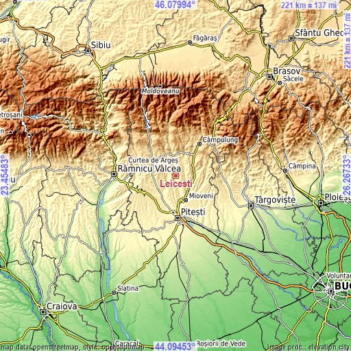
| \ | Map #1 | Topo.Map |
| Scale [m] | 355..673 m | × |
| Scale [ft] | 1165..2208 ft | × |
| Average | 499.5 m = 1639 ft | × |
| Width | 6.9 km = 4.3 mi | 220.8 km = 137.2 mi |
| Height | 6.9 km = 4.3 mi | 220.7 km = 137.1 mi |
| ↑Max Latitude | 45.126874° | 46.07994° |
| Latitude at center | 45.09586° | 45.09586° |
| ↓Min Latitude | 45.06483° | 44.09453° |
| ← Min Longitude | 24.817135° | 23.45483° |
| Longitude center | 24.86108° | 24.86108° |
| →Max Longitude | 24.905025° | 26.26733° |
Nearby cities:
Cities around Leicești sort by population:
• Coşeşti elevation 366 m
3.3 km,  172°
172°
• Stâlpeni 356 m
9.7 km,  121°
121°
• Mălureni 404 m
4.8 km,  275°
275°
• Bălileşti 476 m
6.5 km, 119°
• Dărmăneşti 344 m
9.3 km,  160°
160°
• Vlădești 461 m
7.4 km,  35°
35°
• Retevoiești 426 m
5.2 km,  339°
339°
• Bădești 449 m
8.4 km,  359°
359°
• Stroești 439 m
6.4 km,  305°
305°
• Jupânești 376 m
3.4 km,  195°
195°
• Petrești 370 m
6.2 km, 158°
• Budeasa 509 m
8.8 km,  185°
185°
Multilingual:
 En español:
Leicești elevación 418 m.
 En France:
Leicești élévation 418 m.
 Auf Deutsch:
Leicești höhe über dem Meeresspiegel ist 418 m.

Sources and notes:
- [note 1] Map square and city borders are not equal. Map elevation data is calculated only from area inside that square.
- [src 1] Elevation data from geonames database provided with same terms of usage.
- [src 2] The elevation map of Leicești is generated using elevation data from NASA's 3 arcsec (90m) resolution SRTM data.
- [src 3] Base (background) map © OpenStreetMap contributors tiles are generated by Geofabrik and OpenTopoMap.
Copyright & License:
This Leicești Elevation Map is licensed under CC BY-SA. You may reuse any part from this page, if you give a proper credit by linking to this URL:
 More info on terms of use page.