Budeasa elevation
Budeasa (Arges, Comuna Budeasa), Romania elevation is 509 meters and Budeasa elevation in feet is 1670 ft above sea level [src 1]. Budeasa is a seat of a second-order administrative division (feature code) with elevation that is 257 meters (843 ft) bigger than average city elevation in Romania.
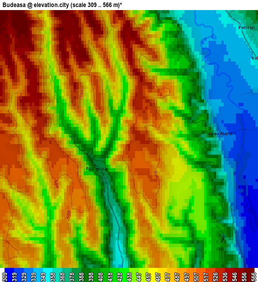
Below is the Elevation map of Budeasa, which displays elevation range with different colors. Scale of the first map is from 309 to 566 m (1014 to 1857 ft) with average elevation of 445.7 meters (=1462 ft) [note 1]
These maps also provides idea of topography and contour of this city, they are displayed at different zoom levels. More info about maps, scale and edge coordinates you can find below images.
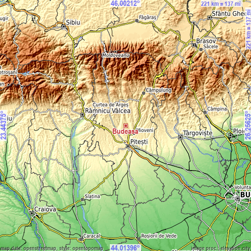
| \ | Map #1 | Topo.Map |
| Scale [m] | 309..566 m | × |
| Scale [ft] | 1014..1857 ft | × |
| Average | 445.7 m = 1462 ft | × |
| Width | 6.91 km = 4.3 mi | 221.1 km = 137.4 mi |
| Height | 6.91 km = 4.3 mi | 221.1 km = 137.4 mi |
| ↑Max Latitude | 45.047727° | 46.00212° |
| Latitude at center | 45.01667° | 45.01667° |
| ↓Min Latitude | 44.985597° | 44.01396° |
| ← Min Longitude | 24.806055° | 23.44375° |
| Longitude center | 24.85° | 24.85° |
| →Max Longitude | 24.893945° | 26.25625° |
Nearby cities:
Cities around Budeasa sort by population:
• Coşeşti elevation 366 m
5.7 km,  13°
13°
• Bălileşti 476 m
8.6 km,  49°
49°
• Miceşti 353 m
7.5 km,  169°
169°
• Budeasa Mică 455 m
7.4 km,  180°
180°
• Dărmăneşti 344 m
3.9 km,  90°
90°
• Purcăreni 316 m
6.1 km,  151°
151°
• Băjești 344 m
7.2 km,  81°
81°
• Jupânești 376 m
5.6 km,  0°
0°
• Bucșenești-Lotași 360 m
9.3 km, 92°
• Leicești 418 m
8.8 km, 5°
• Gălășești 320 m
8.4 km,  216°
216°
• Petrești 370 m
4.3 km, 46°
Multilingual:
 En español:
Budeasa elevación 509 m.
 En France:
Budeasa élévation 509 m.


Sources and notes:
- [note 1] Map square and city borders are not equal. Map elevation data is calculated only from area inside that square.
- [src 1] Elevation data from geonames database provided with same terms of usage.
- [src 2] The elevation map of Budeasa is generated using elevation data from NASA's 3 arcsec (90m) resolution SRTM data.
- [src 3] Base (background) map © OpenStreetMap contributors tiles are generated by Geofabrik and OpenTopoMap.
Copyright & License:
This Budeasa Elevation Map is licensed under CC BY-SA. You may reuse any part from this page, if you give a proper credit by linking to this URL:
 More info on terms of use page.