Dorohoi elevation
Dorohoi (Botoşani, Municipiul Dorohoi), Romania elevation is 151 meters and Dorohoi elevation in feet is 495 ft above sea level [src 1]. Dorohoi is a seat of a second-order administrative division (feature code) with elevation that is 101 meters (331 ft) smaller than average city elevation in Romania.
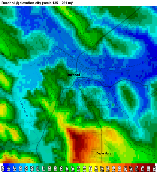
Below is the Elevation map of Dorohoi, which displays elevation range with different colors. Scale of the first map is from 135 to 291 m (443 to 955 ft) with average elevation of 178.1 meters (=584 ft) [note 1]
These maps also provides idea of topography and contour of this city, they are displayed at different zoom levels. More info about maps, scale and edge coordinates you can find below images.
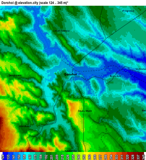
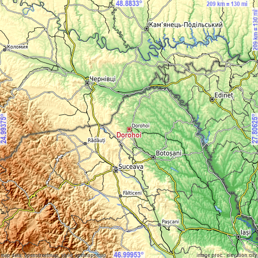
| \ | Map #1 | Map #2 | Topo.Map |
| Scale [m] | 135..291 m | 124..345 m | × |
| Scale [ft] | 443..955 ft | 407..1132 ft | × |
| Average | 178.1 m = 584 ft | 191.9 m = 630 ft | × |
| Width | 6.55 km = 4.1 mi | 13.09 km = 8.1 mi | 209.5 km = 130.2 mi |
| Height | 6.55 km = 4.1 mi | 13.09 km = 8.1 mi | 209.4 km = 130.1 mi |
| ↑Max Latitude | 47.979425° | 48.008834° | 48.8833° |
| Latitude at center | 47.95° | 47.95° | 47.95° |
| ↓Min Latitude | 47.920558° | 47.891099° | 46.99953° |
| ← Min Longitude | 26.356055° | 26.312109° | 24.99375° |
| Longitude center | 26.4° | 26.4° | 26.4° |
| →Max Longitude | 26.443945° | 26.487891° | 27.80625° |
Nearby cities:
Cities around Dorohoi sort by population:
• Şendriceni elevation 217 m
5.4 km,  272°
272°
• Corlăteni 165 m
11.3 km,  99°
99°
• Bucovineni 300 m
12.2 km,  204°
204°
• George Enescu 175 m
11.1 km,  33°
33°
• Broscăuţi 181 m
3.7 km,  90°
90°
• Văculeşti 226 m
7.5 km,  170°
170°
• Brăeşti 238 m
10 km,  158°
158°
• Dumbrăvița 192 m
7.9 km,  14°
14°
• Dimăcheni 119 m
11.7 km,  111°
111°
• Pădureni 180 m
6.8 km,  293°
293°
• Lozna 311 m
9.1 km, 271°
• Străteni 272 m
7.8 km,  259°
259°
Multilingual:
 En español:
Dorohoi elevación 151 m.
 En France:
Dorohoi élévation 151 m.


Sources and notes:
- [note 1] Map square and city borders are not equal. Map elevation data is calculated only from area inside that square.
- [src 1] Elevation data from geonames database provided with same terms of usage.
- [src 2] The elevation map of Dorohoi is generated using elevation data from NASA's 3 arcsec (90m) resolution SRTM data.
- [src 3] Base (background) map © OpenStreetMap contributors tiles are generated by Geofabrik and OpenTopoMap.
Copyright & License:
This Dorohoi Elevation Map is licensed under CC BY-SA. You may reuse any part from this page, if you give a proper credit by linking to this URL:
 More info on terms of use page.