Văculeşti elevation
Văculeşti (Botoşani, Comuna Văculeşti), Romania elevation is 226 meters and Văculeşti elevation in feet is 741 ft above sea level [src 1]. Văculeşti is a seat of a second-order administrative division (feature code) with elevation that is 26 meters (85 ft) smaller than average city elevation in Romania.
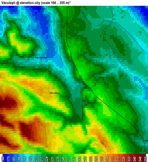
Below is the Elevation map of Văculeşti, which displays elevation range with different colors. Scale of the first map is from 166 to 355 m (545 to 1165 ft) with average elevation of 239.9 meters (=787 ft) [note 1]
These maps also provides idea of topography and contour of this city, they are displayed at different zoom levels. More info about maps, scale and edge coordinates you can find below images.
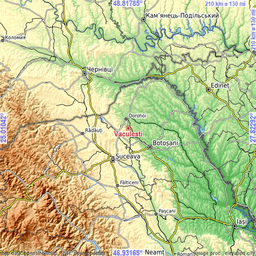
| \ | Map #1 | Topo.Map |
| Scale [m] | 166..355 m | × |
| Scale [ft] | 545..1165 ft | × |
| Average | 239.9 m = 787 ft | × |
| Width | 6.55 km = 4.1 mi | 209.7 km = 130.3 mi |
| Height | 6.55 km = 4.1 mi | 209.7 km = 130.3 mi |
| ↑Max Latitude | 47.912793° | 48.81785° |
| Latitude at center | 47.88333° | 47.88333° |
| ↓Min Latitude | 47.85385° | 46.93165° |
| ← Min Longitude | 26.372725° | 25.01042° |
| Longitude center | 26.41667° | 26.41667° |
| →Max Longitude | 26.460615° | 27.82292° |
Nearby cities:
Cities around Văculeşti sort by population:
• Dorohoi elevation 151 m
7.5 km,  350°
350°
• Zvoriştea 279 m
11.4 km,  240°
240°
• Şendriceni 217 m
10.1 km,  319°
319°
• Corlăteni 165 m
11.4 km,  60°
60°
• Bucovineni 300 m
7.2 km, 239°
• Broscăuţi 181 m
7.8 km,  18°
18°
• Leorda 167 m
7.8 km,  161°
161°
• Brăeşti 238 m
3.1 km,  126°
126°
• Vârfu Câmpului 292 m
7.7 km, 236°
• Dimăcheni 119 m
10.1 km,  72°
72°
• Șerbănești 278 m
10.9 km,  221°
221°
• Străteni 272 m
10.7 km,  303°
303°
Multilingual:
 En español:
Văculeşti elevación 226 m.
 En France:
Văculeşti élévation 226 m.
 Auf Deutsch:
Văculeşti höhe über dem Meeresspiegel ist 226 m.

Sources and notes:
- [note 1] Map square and city borders are not equal. Map elevation data is calculated only from area inside that square.
- [src 1] Elevation data from geonames database provided with same terms of usage.
- [src 2] The elevation map of Văculeşti is generated using elevation data from NASA's 3 arcsec (90m) resolution SRTM data.
- [src 3] Base (background) map © OpenStreetMap contributors tiles are generated by Geofabrik and OpenTopoMap.
Copyright & License:
This Văculeşti Elevation Map is licensed under CC BY-SA. You may reuse any part from this page, if you give a proper credit by linking to this URL:
 More info on terms of use page.