Leorda elevation
Leorda (Botoşani, Comuna Leorda), Romania elevation is 167 meters and Leorda elevation in feet is 548 ft above sea level [src 1]. Leorda is a seat of a second-order administrative division (feature code) with elevation that is 85 meters (279 ft) smaller than average city elevation in Romania.
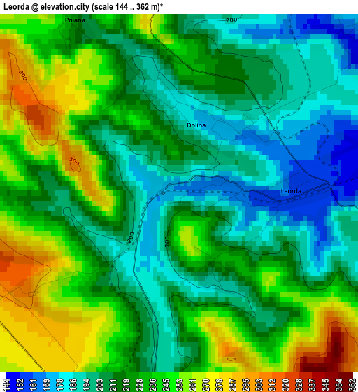
Below is the Elevation map of Leorda, which displays elevation range with different colors. Scale of the first map is from 144 to 362 m (472 to 1188 ft) with average elevation of 222.3 meters (=729 ft) [note 1]
These maps also provides idea of topography and contour of this city, they are displayed at different zoom levels. More info about maps, scale and edge coordinates you can find below images.
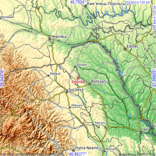
| \ | Map #1 | Topo.Map |
| Scale [m] | 144..362 m | × |
| Scale [ft] | 472..1188 ft | × |
| Average | 222.3 m = 729 ft | × |
| Width | 6.56 km = 4.1 mi | 210 km = 130.5 mi |
| Height | 6.56 km = 4.1 mi | 210 km = 130.5 mi |
| ↑Max Latitude | 47.846171° | 48.7524° |
| Latitude at center | 47.81667° | 47.81667° |
| ↓Min Latitude | 47.787152° | 46.86377° |
| ← Min Longitude | 26.406055° | 25.04375° |
| Longitude center | 26.45° | 26.45° |
| →Max Longitude | 26.493945° | 27.85625° |
Nearby cities:
Cities around Leorda sort by population:
• Zvoriştea elevation 279 m
12.6 km,  278°
278°
• Bucecea 265 m
5.7 km,  192°
192°
• Vlădeni 273 m
12.2 km,  155°
155°
• Bucovineni 300 m
9.5 km,  293°
293°
• Roma 128 m
11.4 km,  80°
80°
• Hănțești 267 m
8.9 km,  219°
219°
• Văculeşti 226 m
7.8 km,  341°
341°
• Brăeşti 238 m
5.6 km,  0°
0°
• Vârfu Câmpului 292 m
9.5 km, 289°
• Cătămărești-Deal 200 m
12.3 km,  115°
115°
• Șerbănești 278 m
9.8 km,  265°
265°
• Mândrești 325 m
9.6 km, 164°
Multilingual:
 En español:
Leorda elevación 167 m.
 En France:
Leorda élévation 167 m.


Sources and notes:
- [note 1] Map square and city borders are not equal. Map elevation data is calculated only from area inside that square.
- [src 1] Elevation data from geonames database provided with same terms of usage.
- [src 2] The elevation map of Leorda is generated using elevation data from NASA's 3 arcsec (90m) resolution SRTM data.
- [src 3] Base (background) map © OpenStreetMap contributors tiles are generated by Geofabrik and OpenTopoMap.
Copyright & License:
This Leorda Elevation Map is licensed under CC BY-SA. You may reuse any part from this page, if you give a proper credit by linking to this URL:
 More info on terms of use page.