Pădureni elevation
Pădureni (Botoşani, Comuna Şendriceni), Romania elevation is 180 meters and Pădureni elevation in feet is 591 ft above sea level [src 1]. Pădureni is a populated place (feature code) with elevation that is 72 meters (236 ft) smaller than average city elevation in Romania.
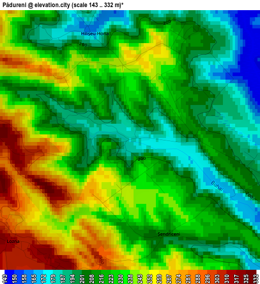
Below is the Elevation map of Pădureni, which displays elevation range with different colors. Scale of the first map is from 143 to 332 m (469 to 1089 ft) with average elevation of 224.3 meters (=736 ft) [note 1]
These maps also provides idea of topography and contour of this city, they are displayed at different zoom levels. More info about maps, scale and edge coordinates you can find below images.
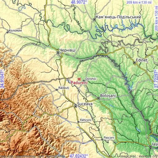
| \ | Map #1 | Topo.Map |
| Scale [m] | 143..332 m | × |
| Scale [ft] | 469..1089 ft | × |
| Average | 224.3 m = 736 ft | × |
| Width | 6.54 km = 4.1 mi | 209.4 km = 130.1 mi |
| Height | 6.54 km = 4.1 mi | 209.3 km = 130.1 mi |
| ↑Max Latitude | 48.003751° | 48.9072° |
| Latitude at center | 47.97434° | 47.97434° |
| ↓Min Latitude | 47.944912° | 47.02432° |
| ← Min Longitude | 26.272775° | 24.91047° |
| Longitude center | 26.31672° | 26.31672° |
| →Max Longitude | 26.360665° | 27.72297° |
Nearby cities:
Cities around Pădureni sort by population:
• Dorohoi elevation 151 m
6.8 km,  113°
113°
• Dersca 382 m
8.7 km,  276°
276°
• Mihăileni 332 m
12.4 km,  266°
266°
• Şendriceni 217 m
2.7 km,  161°
161°
• Ibăneşti 291 m
10.9 km,  19°
19°
• Hilişeu-Horia 201 m
8.2 km,  322°
322°
• Broscăuţi 181 m
10.3 km, 105°
• Pomârla 247 m
10.3 km,  359°
359°
• Dumbrăvița 192 m
9.6 km,  58°
58°
• Străteni 272 m
4.4 km,  199°
199°
• Lozna 311 m
3.9 km,  229°
229°
• Cândeşti 302 m
9.8 km,  242°
242°
Multilingual:
 En español:
Pădureni elevación 180 m.
 En France:
Pădureni élévation 180 m.
 Auf Deutsch:
Pădureni höhe über dem Meeresspiegel ist 180 m.

Sources and notes:
- [note 1] Map square and city borders are not equal. Map elevation data is calculated only from area inside that square.
- [src 1] Elevation data from geonames database provided with same terms of usage.
- [src 2] The elevation map of Pădureni is generated using elevation data from NASA's 3 arcsec (90m) resolution SRTM data.
- [src 3] Base (background) map © OpenStreetMap contributors tiles are generated by Geofabrik and OpenTopoMap.
Copyright & License:
This Pădureni Elevation Map is licensed under CC BY-SA. You may reuse any part from this page, if you give a proper credit by linking to this URL:
 More info on terms of use page.