Cândeşti elevation
Cândeşti (Botoşani, Comuna Cândeşti), Romania elevation is 302 meters and Cândeşti elevation in feet is 991 ft above sea level [src 1]. Cândeşti is a seat of a second-order administrative division (feature code) with elevation that is 50 meters (164 ft) bigger than average city elevation in Romania.
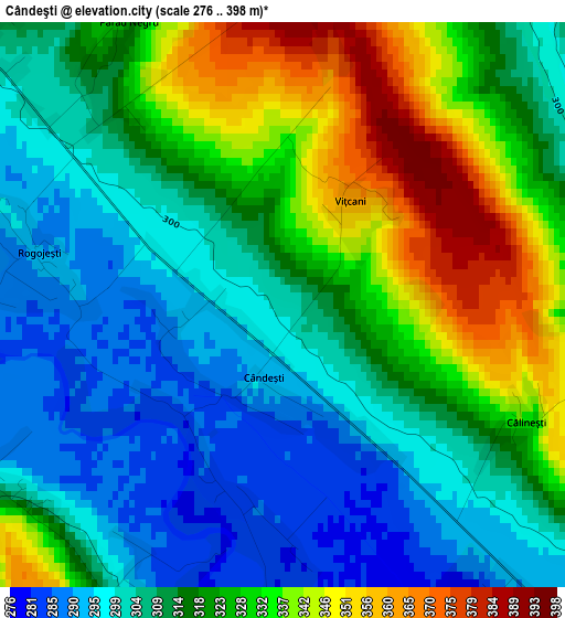
Below is the Elevation map of Cândeşti, which displays elevation range with different colors. Scale of the first map is from 276 to 398 m (906 to 1306 ft) with average elevation of 316.8 meters (=1039 ft) [note 1]
These maps also provides idea of topography and contour of this city, they are displayed at different zoom levels. More info about maps, scale and edge coordinates you can find below images.
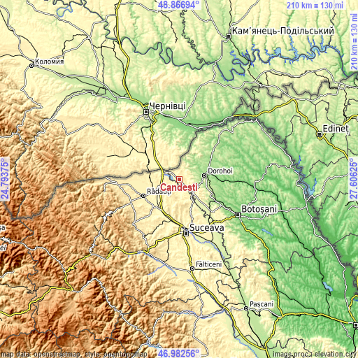
| \ | Map #1 | Topo.Map |
| Scale [m] | 276..398 m | × |
| Scale [ft] | 906..1306 ft | × |
| Average | 316.8 m = 1039 ft | × |
| Width | 6.55 km = 4.1 mi | 209.5 km = 130.2 mi |
| Height | 6.55 km = 4.1 mi | 209.5 km = 130.2 mi |
| ↑Max Latitude | 47.962765° | 48.86694° |
| Latitude at center | 47.93333° | 47.93333° |
| ↓Min Latitude | 47.903878° | 46.98256° |
| ← Min Longitude | 26.156055° | 24.79375° |
| Longitude center | 26.2° | 26.2° |
| →Max Longitude | 26.243945° | 27.60625° |
Nearby cities:
Cities around Cândeşti sort by population:
• Siret elevation 319 m
10.1 km,  280°
280°
• Calafindeşti 422 m
11.2 km,  213°
213°
• Dersca 382 m
5.6 km,  0°
0°
• Mihăileni 332 m
5.3 km,  314°
314°
• Şendriceni 217 m
9.8 km,  77°
77°
• Bălcăuţi 374 m
10.6 km,  243°
243°
• Zamostea 296 m
7.4 km,  180°
180°
• Grămeşti 293 m
4.2 km, 243°
• Negostina 354 m
8.9 km,  262°
262°
• Pădureni 180 m
9.8 km,  62°
62°
• Străteni 272 m
7.2 km,  86°
86°
• Lozna 311 m
6.1 km,  70°
70°
Multilingual:
 En español:
Cândeşti elevación 302 m.
 En France:
Cândeşti élévation 302 m.
 Auf Deutsch:
Cândeşti höhe über dem Meeresspiegel ist 302 m.

Sources and notes:
- [note 1] Map square and city borders are not equal. Map elevation data is calculated only from area inside that square.
- [src 1] Elevation data from geonames database provided with same terms of usage.
- [src 2] The elevation map of Cândeşti is generated using elevation data from NASA's 3 arcsec (90m) resolution SRTM data.
- [src 3] Base (background) map © OpenStreetMap contributors tiles are generated by Geofabrik and OpenTopoMap.
Copyright & License:
This Cândeşti Elevation Map is licensed under CC BY-SA. You may reuse any part from this page, if you give a proper credit by linking to this URL:
 More info on terms of use page.