Zamostea elevation
Zamostea (Suceava, Comuna Zamostea), Romania elevation is 296 meters and Zamostea elevation in feet is 971 ft above sea level [src 1]. Zamostea is a seat of a second-order administrative division (feature code) with elevation that is 44 meters (144 ft) bigger than average city elevation in Romania.
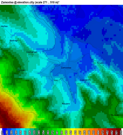
Below is the Elevation map of Zamostea, which displays elevation range with different colors. Scale of the first map is from 271 to 510 m (889 to 1673 ft) with average elevation of 324.3 meters (=1064 ft) [note 1]
These maps also provides idea of topography and contour of this city, they are displayed at different zoom levels. More info about maps, scale and edge coordinates you can find below images.
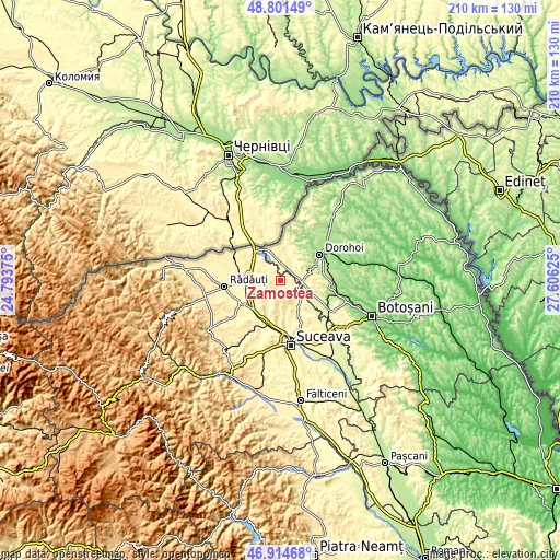
| \ | Map #1 | Topo.Map |
| Scale [m] | 271..510 m | × |
| Scale [ft] | 889..1673 ft | × |
| Average | 324.3 m = 1064 ft | × |
| Width | 6.56 km = 4.1 mi | 209.8 km = 130.4 mi |
| Height | 6.56 km = 4.1 mi | 209.8 km = 130.4 mi |
| ↑Max Latitude | 47.896143° | 48.80149° |
| Latitude at center | 47.86667° | 47.86667° |
| ↓Min Latitude | 47.837181° | 46.91468° |
| ← Min Longitude | 26.156055° | 24.79375° |
| Longitude center | 26.2° | 26.2° |
| →Max Longitude | 26.243945° | 27.60625° |
Nearby cities:
Cities around Zamostea sort by population:
• Zvoriştea elevation 279 m
7.2 km,  120°
120°
• Calafindeşti 422 m
6.5 km,  253°
253°
• Bucovineni 300 m
10.1 km,  100°
100°
• Bălcăuţi 374 m
9.9 km,  286°
286°
• Grămeşti 293 m
6.7 km,  326°
326°
• Vârfu Câmpului 292 m
10 km, 103°
• Șerbăuți 392 m
6.3 km,  225°
225°
• Negostina 354 m
10.8 km,  305°
305°
• Călinești 369 m
7.9 km,  206°
206°
• Șerbănești 278 m
10.9 km,  125°
125°
• Străteni 272 m
10.6 km,  42°
42°
• Cândeşti 302 m
7.4 km,  0°
0°
Multilingual:
 En español:
Zamostea elevación 296 m.
 En France:
Zamostea élévation 296 m.
 Auf Deutsch:
Zamostea höhe über dem Meeresspiegel ist 296 m.

Sources and notes:
- [note 1] Map square and city borders are not equal. Map elevation data is calculated only from area inside that square.
- [src 1] Elevation data from geonames database provided with same terms of usage.
- [src 2] The elevation map of Zamostea is generated using elevation data from NASA's 3 arcsec (90m) resolution SRTM data.
- [src 3] Base (background) map © OpenStreetMap contributors tiles are generated by Geofabrik and OpenTopoMap.
Copyright & License:
This Zamostea Elevation Map is licensed under CC BY-SA. You may reuse any part from this page, if you give a proper credit by linking to this URL:
 More info on terms of use page.