Șerbăuți elevation
Șerbăuți (Suceava, Comuna Şerbăuţi), Romania elevation is 392 meters and Șerbăuți elevation in feet is 1286 ft above sea level [src 1]. Șerbăuți is a seat of a second-order administrative division (feature code) with elevation that is 140 meters (459 ft) bigger than average city elevation in Romania.
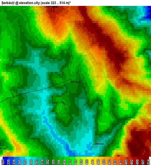
Below is the Elevation map of Șerbăuți, which displays elevation range with different colors. Scale of the first map is from 323 to 514 m (1060 to 1686 ft) with average elevation of 413.3 meters (=1356 ft) [note 1]
These maps also provides idea of topography and contour of this city, they are displayed at different zoom levels. More info about maps, scale and edge coordinates you can find below images.
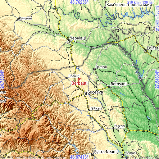
| \ | Map #1 | Topo.Map |
| Scale [m] | 323..514 m | × |
| Scale [ft] | 1060..1686 ft | × |
| Average | 413.3 m = 1356 ft | × |
| Width | 6.56 km = 4.1 mi | 210 km = 130.5 mi |
| Height | 6.56 km = 4.1 mi | 209.9 km = 130.4 mi |
| ↑Max Latitude | 47.856335° | 48.76238° |
| Latitude at center | 47.82684° | 47.82684° |
| ↓Min Latitude | 47.797328° | 46.87413° |
| ← Min Longitude | 26.096145° | 24.73384° |
| Longitude center | 26.14009° | 26.14009° |
| →Max Longitude | 26.184035° | 27.54634° |
Nearby cities:
Cities around Șerbăuți sort by population:
• Zvoriştea elevation 279 m
10.7 km,  86°
86°
• Dărmăneşti 340 m
10.4 km,  175°
175°
• Calafindeşti 422 m
3.1 km,  325°
325°
• Grăniceşti 357 m
5.6 km,  258°
258°
• Dorneşti 346 m
11.3 km,  296°
296°
• Satu Mare 337 m
9.2 km,  274°
274°
• Bălcăuţi 374 m
8.8 km, 325°
• Zamostea 296 m
6.3 km,  45°
45°
• Grămeşti 293 m
10 km,  4°
4°
• Măriței 402 m
8.3 km, 176°
• Țibeni 329 m
8.7 km, 262°
• Călinești 369 m
2.8 km,  159°
159°
Multilingual:
 En español:
Șerbăuți elevación 392 m.
 En France:
Șerbăuți élévation 392 m.
 Auf Deutsch:
Șerbăuți höhe über dem Meeresspiegel ist 392 m.

Sources and notes:
- [note 1] Map square and city borders are not equal. Map elevation data is calculated only from area inside that square.
- [src 1] Elevation data from geonames database provided with same terms of usage.
- [src 2] The elevation map of Șerbăuți is generated using elevation data from NASA's 3 arcsec (90m) resolution SRTM data.
- [src 3] Base (background) map © OpenStreetMap contributors tiles are generated by Geofabrik and OpenTopoMap.
Copyright & License:
This Șerbăuți Elevation Map is licensed under CC BY-SA. You may reuse any part from this page, if you give a proper credit by linking to this URL:
 More info on terms of use page.