Dumbrăvița elevation
Dumbrăvița (Botoşani, Comuna Ibăneşti), Romania elevation is 192 meters and Dumbrăvița elevation in feet is 630 ft above sea level [src 1]. Dumbrăvița is a populated place (feature code) with elevation that is 60 meters (197 ft) smaller than average city elevation in Romania.
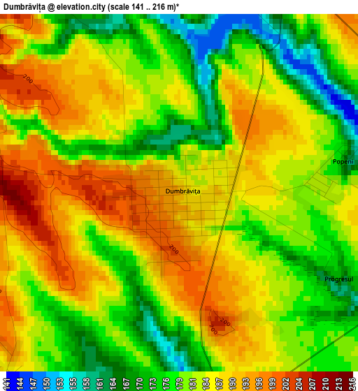
Below is the Elevation map of Dumbrăvița, which displays elevation range with different colors. Scale of the first map is from 141 to 216 m (463 to 709 ft) with average elevation of 182.6 meters (=599 ft) [note 1]
These maps also provides idea of topography and contour of this city, they are displayed at different zoom levels. More info about maps, scale and edge coordinates you can find below images.
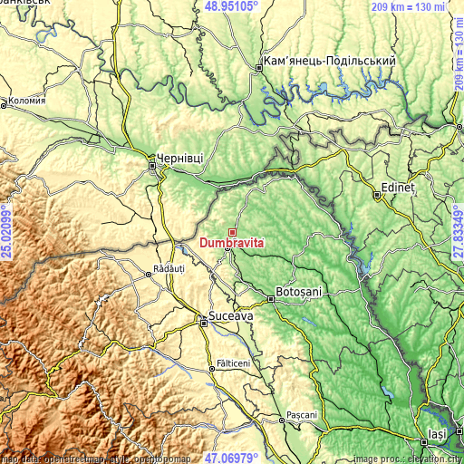
| \ | Map #1 | Topo.Map |
| Scale [m] | 141..216 m | × |
| Scale [ft] | 463..709 ft | × |
| Average | 182.6 m = 599 ft | × |
| Width | 6.54 km = 4.1 mi | 209.2 km = 130 mi |
| Height | 6.54 km = 4.1 mi | 209.2 km = 130 mi |
| ↑Max Latitude | 48.048386° | 48.95105° |
| Latitude at center | 48.019° | 48.019° |
| ↓Min Latitude | 47.989597° | 47.06979° |
| ← Min Longitude | 26.383295° | 25.02099° |
| Longitude center | 26.42724° | 26.42724° |
| →Max Longitude | 26.471185° | 27.83349° |
Nearby cities:
Cities around Dumbrăvița sort by population:
• Dorohoi elevation 151 m
7.9 km,  194°
194°
• Suharău 193 m
12.7 km,  356°
356°
• Şendriceni 217 m
10.5 km,  224°
224°
• Ibăneşti 291 m
7 km,  319°
319°
• Cristineşti 239 m
9.6 km,  340°
340°
• George Enescu 175 m
4.5 km,  69°
69°
• Broscăuţi 181 m
7.9 km,  167°
167°
• Pomârla 247 m
9.8 km,  302°
302°
• Cordăreni 181 m
12.3 km,  108°
108°
• Dumeni 135 m
8.7 km,  98°
98°
• Mlenăuți 154 m
12.8 km,  21°
21°
• Pădureni 180 m
9.6 km,  238°
238°
Multilingual:
 En español:
Dumbrăvița elevación 192 m.
 En France:
Dumbrăvița élévation 192 m.
 Auf Deutsch:
Dumbrăvița höhe über dem Meeresspiegel ist 192 m.

Sources and notes:
- [note 1] Map square and city borders are not equal. Map elevation data is calculated only from area inside that square.
- [src 1] Elevation data from geonames database provided with same terms of usage.
- [src 2] The elevation map of Dumbrăvița is generated using elevation data from NASA's 3 arcsec (90m) resolution SRTM data.
- [src 3] Base (background) map © OpenStreetMap contributors tiles are generated by Geofabrik and OpenTopoMap.
Copyright & License:
This Dumbrăvița Elevation Map is licensed under CC BY-SA. You may reuse any part from this page, if you give a proper credit by linking to this URL:
 More info on terms of use page.