Negrilești elevation
Negrilești (Bistriţa-Năsăud, Comuna Negrileşti), Romania elevation is 333 meters and Negrilești elevation in feet is 1093 ft above sea level [src 1]. Negrilești is a seat of a second-order administrative division (feature code) with elevation that is 81 meters (266 ft) bigger than average city elevation in Romania.
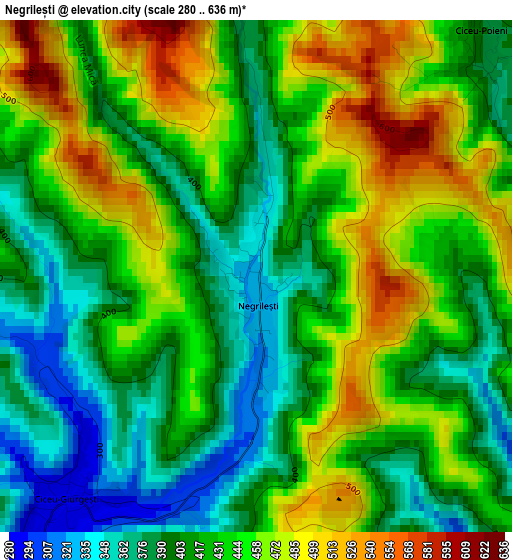
Below is the Elevation map of Negrilești, which displays elevation range with different colors. Scale of the first map is from 280 to 636 m (919 to 2087 ft) with average elevation of 428.4 meters (=1406 ft) [note 1]
These maps also provides idea of topography and contour of this city, they are displayed at different zoom levels. More info about maps, scale and edge coordinates you can find below images.
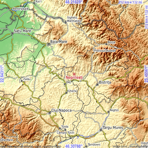
| \ | Map #1 | Topo.Map |
| Scale [m] | 280..636 m | × |
| Scale [ft] | 919..2087 ft | × |
| Average | 428.4 m = 1406 ft | × |
| Width | 6.63 km = 4.1 mi | 212.2 km = 131.9 mi |
| Height | 6.63 km = 4.1 mi | 212.2 km = 131.9 mi |
| ↑Max Latitude | 47.30049° | 48.21628° |
| Latitude at center | 47.27068° | 47.27068° |
| ↓Min Latitude | 47.240853° | 46.30788° |
| ← Min Longitude | 24.005415° | 22.64311° |
| Longitude center | 24.04936° | 24.04936° |
| →Max Longitude | 24.093305° | 25.45561° |
Nearby cities:
Cities around Negrilești sort by population:
• Căianu Mic elevation 276 m
8.7 km,  118°
118°
• Ciceu-Giurgeşti 312 m
3.4 km,  227°
227°
• Uriu 247 m
7.9 km,  179°
179°
• Braniştea 309 m
11.6 km,  173°
173°
• Reteag 250 m
8.6 km,  195°
195°
• Spermezeu 336 m
8.3 km,  66°
66°
• Chiuiești 323 m
13.4 km,  282°
282°
• Breaza 515 m
9 km,  6°
6°
• Cristeștii Ciceului 248 m
9.3 km,  157°
157°
• Dobric 283 m
6.5 km,  114°
114°
• Sânmărghita 242 m
13.4 km, 198°
• Ciceu-Mihăiești 250 m
11 km,  210°
210°
Multilingual:
 En español:
Negrilești elevación 333 m.
 En France:
Negrilești élévation 333 m.
 Auf Deutsch:
Negrilești höhe über dem Meeresspiegel ist 333 m.

Sources and notes:
- [note 1] Map square and city borders are not equal. Map elevation data is calculated only from area inside that square.
- [src 1] Elevation data from geonames database provided with same terms of usage.
- [src 2] The elevation map of Negrilești is generated using elevation data from NASA's 3 arcsec (90m) resolution SRTM data.
- [src 3] Base (background) map © OpenStreetMap contributors tiles are generated by Geofabrik and OpenTopoMap.
Copyright & License:
This Negrilești Elevation Map is licensed under CC BY-SA. You may reuse any part from this page, if you give a proper credit by linking to this URL:
 More info on terms of use page.