Dobric elevation
Dobric (Bistriţa-Năsăud, Comuna Căianu), Romania elevation is 283 meters and Dobric elevation in feet is 928 ft above sea level [src 1]. Dobric is a populated place (feature code) with elevation that is 31 meters (102 ft) bigger than average city elevation in Romania.
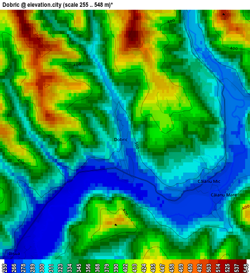
Below is the Elevation map of Dobric, which displays elevation range with different colors. Scale of the first map is from 255 to 548 m (837 to 1798 ft) with average elevation of 351.5 meters (=1153 ft) [note 1]
These maps also provides idea of topography and contour of this city, they are displayed at different zoom levels. More info about maps, scale and edge coordinates you can find below images.
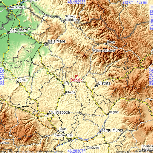
| \ | Map #1 | Topo.Map |
| Scale [m] | 255..548 m | × |
| Scale [ft] | 837..1798 ft | × |
| Average | 351.5 m = 1153 ft | × |
| Width | 6.63 km = 4.1 mi | 212.3 km = 131.9 mi |
| Height | 6.63 km = 4.1 mi | 212.3 km = 131.9 mi |
| ↑Max Latitude | 47.276723° | 48.19293° |
| Latitude at center | 47.2469° | 47.2469° |
| ↓Min Latitude | 47.21706° | 46.28367° |
| ← Min Longitude | 24.083825° | 22.72152° |
| Longitude center | 24.12777° | 24.12777° |
| →Max Longitude | 24.171715° | 25.53402° |
Nearby cities:
Cities around Dobric sort by population:
• Beclean elevation 257 m
8.2 km,  149°
149°
• Căianu Mic 276 m
2.3 km,  131°
131°
• Ciceu-Giurgeşti 312 m
8.4 km,  272°
272°
• Uriu 247 m
7.9 km,  228°
228°
• Braniştea 309 m
10 km,  207°
207°
• Reteag 250 m
10 km,  235°
235°
• Spermezeu 336 m
6.1 km,  15°
15°
• Chiuza 272 m
9.3 km,  99°
99°
• Cireșoaia 460 m
12.6 km,  203°
203°
• Negrilești 333 m
6.5 km,  294°
294°
• Cociu 270 m
9.5 km,  123°
123°
• Cristeștii Ciceului 248 m
6.4 km, 201°
Multilingual:
 En español:
Dobric elevación 283 m.
 En France:
Dobric élévation 283 m.


Sources and notes:
- [note 1] Map square and city borders are not equal. Map elevation data is calculated only from area inside that square.
- [src 1] Elevation data from geonames database provided with same terms of usage.
- [src 2] The elevation map of Dobric is generated using elevation data from NASA's 3 arcsec (90m) resolution SRTM data.
- [src 3] Base (background) map © OpenStreetMap contributors tiles are generated by Geofabrik and OpenTopoMap.
Copyright & License:
This Dobric Elevation Map is licensed under CC BY-SA. You may reuse any part from this page, if you give a proper credit by linking to this URL:
 More info on terms of use page.