Uriu elevation
Uriu (Bistriţa-Năsăud, Comuna Uriu), Romania elevation is 247 meters and Uriu elevation in feet is 810 ft above sea level [src 1]. Uriu is a seat of a second-order administrative division (feature code) with elevation that is 5 meters (16 ft) smaller than average city elevation in Romania.
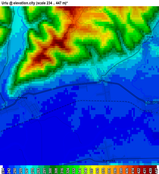
Below is the Elevation map of Uriu, which displays elevation range with different colors. Scale of the first map is from 234 to 447 m (768 to 1467 ft) with average elevation of 278.1 meters (=912 ft) [note 1]
These maps also provides idea of topography and contour of this city, they are displayed at different zoom levels. More info about maps, scale and edge coordinates you can find below images.
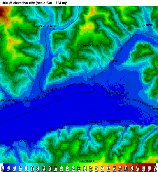
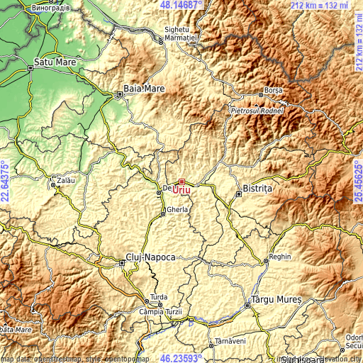
| \ | Map #1 | Map #2 | Topo.Map |
| Scale [m] | 234..447 m | 230..724 m | × |
| Scale [ft] | 768..1467 ft | 755..2375 ft | × |
| Average | 278.1 m = 912 ft | 327.1 m = 1073 ft | × |
| Width | 6.64 km = 4.1 mi | 13.28 km = 8.3 mi | 212.5 km = 132 mi |
| Height | 6.64 km = 4.1 mi | 13.28 km = 8.3 mi | 212.5 km = 132 mi |
| ↑Max Latitude | 47.22985° | 47.259683° | 48.14687° |
| Latitude at center | 47.2° | 47.2° | 47.2° |
| ↓Min Latitude | 47.170133° | 47.14025° | 46.23593° |
| ← Min Longitude | 24.006055° | 23.962109° | 22.64375° |
| Longitude center | 24.05° | 24.05° | 24.05° |
| →Max Longitude | 24.093945° | 24.137891° | 25.45625° |
Nearby cities:
Cities around Uriu sort by population:
• Beclean elevation 257 m
10.2 km,  100°
100°
• Căianu Mic 276 m
8.4 km,  63°
63°
• Ciceu-Giurgeşti 312 m
6.1 km,  335°
335°
• Braniştea 309 m
3.9 km,  161°
161°
• Unguraş 310 m
9.3 km,  180°
180°
• Reteag 250 m
2.4 km,  258°
258°
• Cireșoaia 460 m
6.4 km,  171°
171°
• Negrilești 333 m
7.9 km,  359°
359°
• Cristeștii Ciceului 248 m
3.6 km, 102°
• Dobric 283 m
7.9 km,  48°
48°
• Sânmărghita 242 m
6.4 km,  220°
220°
• Ciceu-Mihăiești 250 m
5.9 km,  254°
254°
Multilingual:
 En español:
Uriu elevación 247 m.
 En France:
Uriu élévation 247 m.


Sources and notes:
- [note 1] Map square and city borders are not equal. Map elevation data is calculated only from area inside that square.
- [src 1] Elevation data from geonames database provided with same terms of usage.
- [src 2] The elevation map of Uriu is generated using elevation data from NASA's 3 arcsec (90m) resolution SRTM data.
- [src 3] Base (background) map © OpenStreetMap contributors tiles are generated by Geofabrik and OpenTopoMap.
Copyright & License:
This Uriu Elevation Map is licensed under CC BY-SA. You may reuse any part from this page, if you give a proper credit by linking to this URL:
 More info on terms of use page.