Breaza elevation
Breaza (Bistriţa-Năsăud, Comuna Negrileşti), Romania elevation is 515 meters and Breaza elevation in feet is 1690 ft above sea level [src 1]. Breaza is a populated place (feature code) with elevation that is 263 meters (863 ft) bigger than average city elevation in Romania.
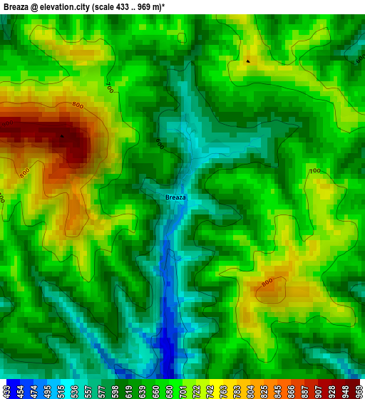
Below is the Elevation map of Breaza, which displays elevation range with different colors. Scale of the first map is from 433 to 969 m (1421 to 3179 ft) with average elevation of 662.3 meters (=2173 ft) [note 1]
These maps also provides idea of topography and contour of this city, they are displayed at different zoom levels. More info about maps, scale and edge coordinates you can find below images.
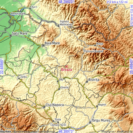
| \ | Map #1 | Topo.Map |
| Scale [m] | 433..969 m | × |
| Scale [ft] | 1421..3179 ft | × |
| Average | 662.3 m = 2173 ft | × |
| Width | 6.62 km = 4.1 mi | 211.9 km = 131.7 mi |
| Height | 6.62 km = 4.1 mi | 211.9 km = 131.7 mi |
| ↑Max Latitude | 47.380845° | 48.29523° |
| Latitude at center | 47.35108° | 47.35108° |
| ↓Min Latitude | 47.321298° | 46.38973° |
| ← Min Longitude | 24.018255° | 22.65595° |
| Longitude center | 24.0622° | 24.0622° |
| →Max Longitude | 24.106145° | 25.46845° |
Nearby cities:
Cities around Breaza sort by population:
• Suciu de Sus elevation 418 m
9.4 km,  346°
346°
• Căianu Mic 276 m
14.7 km,  153°
153°
• Ciceu-Giurgeşti 312 m
11.8 km,  196°
196°
• Răpănaşu 487 m
9.8 km,  68°
68°
• Spermezeu 336 m
8.7 km,  130°
130°
• Groșii Țibleșului 491 m
15.4 km,  0°
0°
• Chiuiești 323 m
15.3 km,  246°
246°
• Suciu de Jos 379 m
12.1 km,  330°
330°
• Negrilești 333 m
9 km,  186°
186°
• Dobric 283 m
12.6 km,  156°
156°
• Agrieș 389 m
7.7 km,  45°
45°
• Târlişua 487 m
9.8 km, 68°
Multilingual:
 En español:
Breaza elevación 515 m.
 En France:
Breaza élévation 515 m.


Sources and notes:
- [note 1] Map square and city borders are not equal. Map elevation data is calculated only from area inside that square.
- [src 1] Elevation data from geonames database provided with same terms of usage.
- [src 2] The elevation map of Breaza is generated using elevation data from NASA's 3 arcsec (90m) resolution SRTM data.
- [src 3] Base (background) map © OpenStreetMap contributors tiles are generated by Geofabrik and OpenTopoMap.
Copyright & License:
This Breaza Elevation Map is licensed under CC BY-SA. You may reuse any part from this page, if you give a proper credit by linking to this URL:
 More info on terms of use page.