Păcureţi elevation
Păcureţi (Prahova, Comuna Păcureţi), Romania elevation is 291 meters and Păcureţi elevation in feet is 955 ft above sea level [src 1]. Păcureţi is a seat of a second-order administrative division (feature code) with elevation that is 39 meters (128 ft) bigger than average city elevation in Romania.
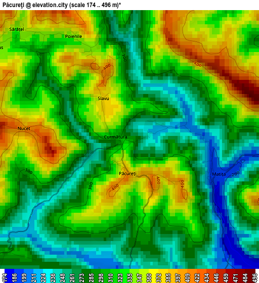
Below is the Elevation map of Păcureţi, which displays elevation range with different colors. Scale of the first map is from 174 to 496 m (571 to 1627 ft) with average elevation of 308.8 meters (=1013 ft) [note 1]
These maps also provides idea of topography and contour of this city, they are displayed at different zoom levels. More info about maps, scale and edge coordinates you can find below images.
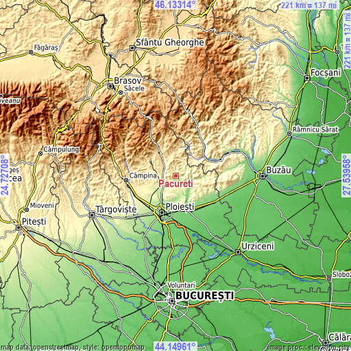
| \ | Map #1 | Topo.Map |
| Scale [m] | 174..496 m | × |
| Scale [ft] | 571..1627 ft | × |
| Average | 308.8 m = 1013 ft | × |
| Width | 6.89 km = 4.3 mi | 220.5 km = 137 mi |
| Height | 6.89 km = 4.3 mi | 220.5 km = 137 mi |
| ↑Max Latitude | 45.180984° | 46.13314° |
| Latitude at center | 45.15° | 45.15° |
| ↓Min Latitude | 45.118999° | 44.14961° |
| ← Min Longitude | 26.089385° | 24.72708° |
| Longitude center | 26.13333° | 26.13333° |
| →Max Longitude | 26.177275° | 27.53958° |
Nearby cities:
Cities around Păcureţi sort by population:
• Vălenii de Munte elevation 353 m
8.7 km,  295°
295°
• Gura Viţioarei 302 m
7.8 km,  270°
270°
• Podenii Noi 206 m
4.5 km,  144°
144°
• Şoimari 234 m
6.4 km,  54°
54°
• Gornet 351 m
6.4 km,  234°
234°
• Podenii Vechi 248 m
6.9 km,  191°
191°
• Surani 362 m
6.1 km,  25°
25°
• Bălțești 219 m
4.5 km,  183°
183°
• Făgetu 293 m
9 km,  260°
260°
• Valea Dulce 178 m
7.1 km,  124°
124°
• Poiana Copăceni 337 m
5.3 km,  287°
287°
• Ariceștii Zeletin 294 m
8.8 km,  24°
24°
Multilingual:
 En español:
Păcureţi elevación 291 m.
 En France:
Păcureţi élévation 291 m.
 Auf Deutsch:
Păcureţi höhe über dem Meeresspiegel ist 291 m.

Sources and notes:
- [note 1] Map square and city borders are not equal. Map elevation data is calculated only from area inside that square.
- [src 1] Elevation data from geonames database provided with same terms of usage.
- [src 2] The elevation map of Păcureţi is generated using elevation data from NASA's 3 arcsec (90m) resolution SRTM data.
- [src 3] Base (background) map © OpenStreetMap contributors tiles are generated by Geofabrik and OpenTopoMap.
Copyright & License:
This Păcureţi Elevation Map is licensed under CC BY-SA. You may reuse any part from this page, if you give a proper credit by linking to this URL:
 More info on terms of use page.