Podenii Vechi elevation
Podenii Vechi (Prahova, Comuna Bălţeşti), Romania elevation is 248 meters and Podenii Vechi elevation in feet is 814 ft above sea level [src 1]. Podenii Vechi is a populated place (feature code) with elevation that is 4 meters (13 ft) smaller than average city elevation in Romania.
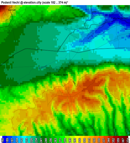
Below is the Elevation map of Podenii Vechi, which displays elevation range with different colors. Scale of the first map is from 182 to 374 m (597 to 1227 ft) with average elevation of 261.6 meters (=858 ft) [note 1]
These maps also provides idea of topography and contour of this city, they are displayed at different zoom levels. More info about maps, scale and edge coordinates you can find below images.
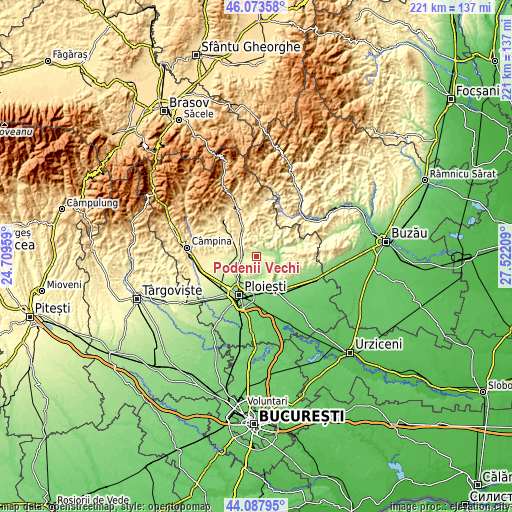
| \ | Map #1 | Topo.Map |
| Scale [m] | 182..374 m | × |
| Scale [ft] | 597..1227 ft | × |
| Average | 261.6 m = 858 ft | × |
| Width | 6.9 km = 4.3 mi | 220.8 km = 137.2 mi |
| Height | 6.9 km = 4.3 mi | 220.8 km = 137.2 mi |
| ↑Max Latitude | 45.120407° | 46.07358° |
| Latitude at center | 45.08939° | 45.08939° |
| ↓Min Latitude | 45.058356° | 44.08795° |
| ← Min Longitude | 26.071895° | 24.70959° |
| Longitude center | 26.11584° | 26.11584° |
| →Max Longitude | 26.159785° | 27.52209° |
Nearby cities:
Cities around Podenii Vechi sort by population:
• Boldeşti-Scăeni elevation 211 m
9 km,  226°
226°
• Lipăneşti 217 m
8.9 km,  240°
240°
• Măgurele 253 m
6.6 km,  280°
280°
• Podenii Noi 206 m
5 km,  52°
52°
• Dumbrăveşti 250 m
9.1 km,  265°
265°
• Gornet 351 m
4.9 km,  308°
308°
• Plopu 181 m
8.5 km,  161°
161°
• Păcureţi 291 m
6.9 km,  11°
11°
• Vărbila 191 m
8 km,  126°
126°
• Bălțești 219 m
2.5 km,  25°
25°
• Seciu 363 m
7.5 km,  212°
212°
• Valea Dulce 178 m
7.7 km,  69°
69°
Multilingual:
 En español:
Podenii Vechi elevación 248 m.
 En France:
Podenii Vechi élévation 248 m.
 Auf Deutsch:
Podenii Vechi höhe über dem Meeresspiegel ist 248 m.

Sources and notes:
- [note 1] Map square and city borders are not equal. Map elevation data is calculated only from area inside that square.
- [src 1] Elevation data from geonames database provided with same terms of usage.
- [src 2] The elevation map of Podenii Vechi is generated using elevation data from NASA's 3 arcsec (90m) resolution SRTM data.
- [src 3] Base (background) map © OpenStreetMap contributors tiles are generated by Geofabrik and OpenTopoMap.
Copyright & License:
This Podenii Vechi Elevation Map is licensed under CC BY-SA. You may reuse any part from this page, if you give a proper credit by linking to this URL:
 More info on terms of use page.