Făgetu elevation
Făgetu (Prahova, Comuna Gura Vitioarei), Romania elevation is 293 meters and Făgetu elevation in feet is 961 ft above sea level [src 1]. Făgetu is a populated place (feature code) with elevation that is 41 meters (135 ft) bigger than average city elevation in Romania.
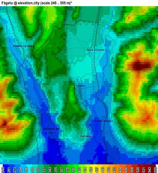
Below is the Elevation map of Făgetu, which displays elevation range with different colors. Scale of the first map is from 249 to 555 m (817 to 1821 ft) with average elevation of 338.6 meters (=1111 ft) [note 1]
These maps also provides idea of topography and contour of this city, they are displayed at different zoom levels. More info about maps, scale and edge coordinates you can find below images.
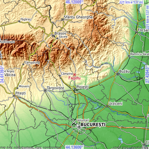
| \ | Map #1 | Topo.Map |
| Scale [m] | 249..555 m | × |
| Scale [ft] | 817..1821 ft | × |
| Average | 338.6 m = 1111 ft | × |
| Width | 6.89 km = 4.3 mi | 220.6 km = 137.1 mi |
| Height | 6.89 km = 4.3 mi | 220.6 km = 137.1 mi |
| ↑Max Latitude | 45.167671° | 46.12005° |
| Latitude at center | 45.13668° | 45.13668° |
| ↓Min Latitude | 45.105672° | 44.13606° |
| ← Min Longitude | 25.976235° | 24.61393° |
| Longitude center | 26.02018° | 26.02018° |
| →Max Longitude | 26.064125° | 27.42643° |
Nearby cities:
Cities around Făgetu sort by population:
• Vălenii de Munte elevation 353 m
5.3 km,  11°
11°
• Vărbilău 394 m
7.6 km,  313°
313°
• Gura Viţioarei 302 m
1.8 km,  34°
34°
• Măgurele 253 m
4.2 km,  165°
165°
• Dumbrăveşti 250 m
6.1 km,  194°
194°
• Gornet 351 m
4.3 km,  121°
121°
• Păcureţi 291 m
9 km,  80°
80°
• Plopeni 229 m
8.5 km,  201°
201°
• Goruna 283 m
8.3 km,  227°
227°
• Bughea de Jos 373 m
4.8 km,  0°
0°
• Poiana Copăceni 337 m
4.9 km,  51°
51°
• Vâlcăneşti 299 m
7.2 km,  251°
251°
Multilingual:
 En español:
Făgetu elevación 293 m.
 En France:
Făgetu élévation 293 m.


Sources and notes:
- [note 1] Map square and city borders are not equal. Map elevation data is calculated only from area inside that square.
- [src 1] Elevation data from geonames database provided with same terms of usage.
- [src 2] The elevation map of Făgetu is generated using elevation data from NASA's 3 arcsec (90m) resolution SRTM data.
- [src 3] Base (background) map © OpenStreetMap contributors tiles are generated by Geofabrik and OpenTopoMap.
Copyright & License:
This Făgetu Elevation Map is licensed under CC BY-SA. You may reuse any part from this page, if you give a proper credit by linking to this URL:
 More info on terms of use page.