Vâlcăneşti elevation
Vâlcăneşti (Prahova, Comuna Vâlcăneşti), Romania elevation is 299 meters and Vâlcăneşti elevation in feet is 981 ft above sea level [src 1]. Vâlcăneşti is a seat of a second-order administrative division (feature code) with elevation that is 47 meters (154 ft) bigger than average city elevation in Romania.
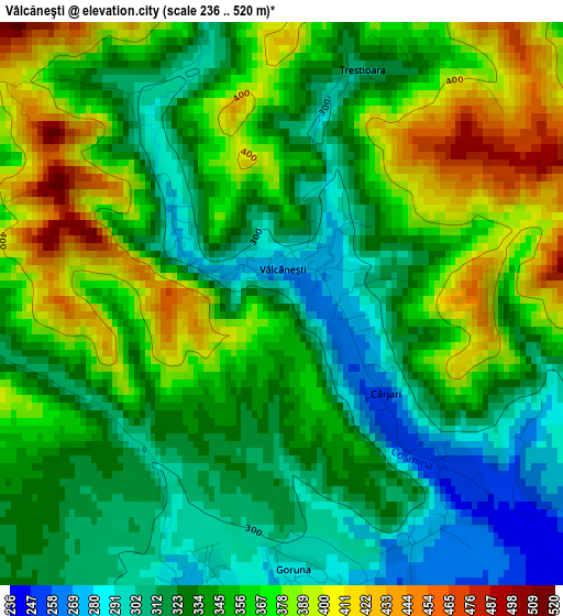
Below is the Elevation map of Vâlcăneşti, which displays elevation range with different colors. Scale of the first map is from 236 to 520 m (774 to 1706 ft) with average elevation of 347.5 meters (=1140 ft) [note 1]
These maps also provides idea of topography and contour of this city, they are displayed at different zoom levels. More info about maps, scale and edge coordinates you can find below images.
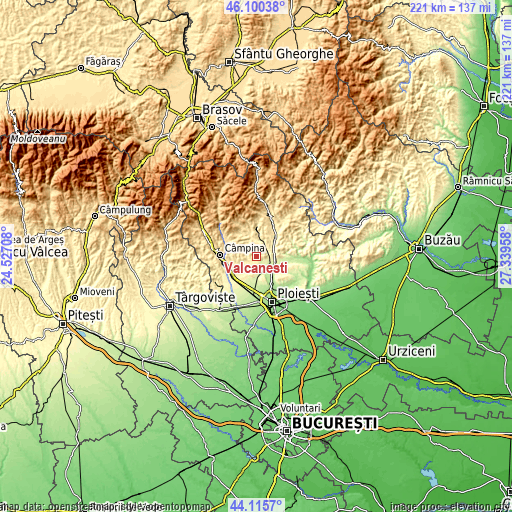
| \ | Map #1 | Topo.Map |
| Scale [m] | 236..520 m | × |
| Scale [ft] | 774..1706 ft | × |
| Average | 347.5 m = 1140 ft | × |
| Width | 6.9 km = 4.3 mi | 220.7 km = 137.1 mi |
| Height | 6.9 km = 4.3 mi | 220.7 km = 137.1 mi |
| ↑Max Latitude | 45.147672° | 46.10038° |
| Latitude at center | 45.11667° | 45.11667° |
| ↓Min Latitude | 45.085651° | 44.1157° |
| ← Min Longitude | 25.889385° | 24.52708° |
| Longitude center | 25.93333° | 25.93333° |
| →Max Longitude | 25.977275° | 27.33958° |
Nearby cities:
Cities around Vâlcăneşti sort by population:
• Plopeni elevation 254 m
7.6 km,  168°
168°
• Vărbilău 394 m
7.5 km,  10°
10°
• Scorţeni 410 m
6.8 km,  254°
254°
• Măgurele 253 m
8.1 km,  103°
103°
• Dumbrăveşti 250 m
6.4 km,  125°
125°
• Cocorăștii Mislii 279 m
3.6 km,  194°
194°
• Bordenii Mari 333 m
5.8 km,  238°
238°
• Plopeni 229 m
6.8 km,  146°
146°
• Făgetu 293 m
7.2 km,  71°
71°
• Goruna 283 m
3.4 km, 168°
• Livadea 359 m
7.8 km,  356°
356°
• Cosmina de Jos 522 m
5.4 km,  313°
313°
Multilingual:
 En español:
Vâlcăneşti elevación 299 m.
 En France:
Vâlcăneşti élévation 299 m.
 Auf Deutsch:
Vâlcăneşti höhe über dem Meeresspiegel ist 299 m.

Sources and notes:
- [note 1] Map square and city borders are not equal. Map elevation data is calculated only from area inside that square.
- [src 1] Elevation data from geonames database provided with same terms of usage.
- [src 2] The elevation map of Vâlcăneşti is generated using elevation data from NASA's 3 arcsec (90m) resolution SRTM data.
- [src 3] Base (background) map © OpenStreetMap contributors tiles are generated by Geofabrik and OpenTopoMap.
Copyright & License:
This Vâlcăneşti Elevation Map is licensed under CC BY-SA. You may reuse any part from this page, if you give a proper credit by linking to this URL:
 More info on terms of use page.