Uda elevation
Uda (Arges, Comuna Uda), Romania elevation is 446 meters and Uda elevation in feet is 1463 ft above sea level [src 1]. Uda is a seat of a second-order administrative division (feature code) with elevation that is 194 meters (636 ft) bigger than average city elevation in Romania.
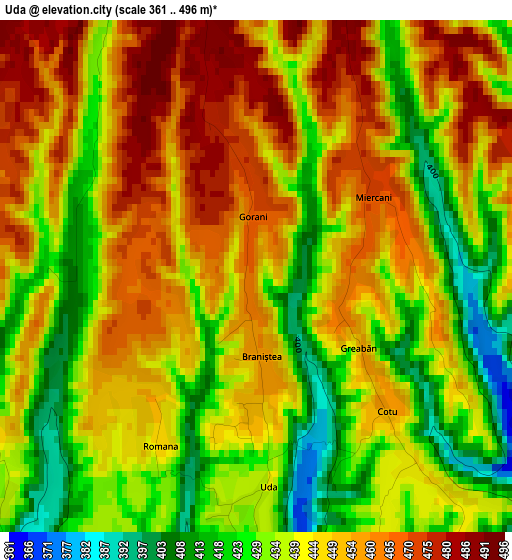
Below is the Elevation map of Uda, which displays elevation range with different colors. Scale of the first map is from 361 to 496 m (1184 to 1627 ft) with average elevation of 443.2 meters (=1454 ft) [note 1]
These maps also provides idea of topography and contour of this city, they are displayed at different zoom levels. More info about maps, scale and edge coordinates you can find below images.
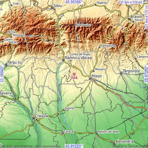
| \ | Map #1 | Topo.Map |
| Scale [m] | 361..496 m | × |
| Scale [ft] | 1184..1627 ft | × |
| Average | 443.2 m = 1454 ft | × |
| Width | 6.92 km = 4.3 mi | 221.4 km = 137.6 mi |
| Height | 6.92 km = 4.3 mi | 221.4 km = 137.6 mi |
| ↑Max Latitude | 44.947781° | 45.90386° |
| Latitude at center | 44.91667° | 44.91667° |
| ↓Min Latitude | 44.885542° | 43.91223° |
| ← Min Longitude | 24.522725° | 23.16042° |
| Longitude center | 24.56667° | 24.56667° |
| →Max Longitude | 24.610615° | 25.97292° |
Nearby cities:
Cities around Uda sort by population:
• Stoileşti elevation 431 m
14.6 km,  262°
262°
• Băbana 366 m
10.7 km,  100°
100°
• Vitomireşti 407 m
14.3 km,  247°
247°
• Cocu 413 m
8.6 km,  130°
130°
• Izvoru de Sus 362 m
12.9 km,  149°
149°
• Dealu Dănicei 434 m
10.7 km, 259°
• Cuca 438 m
5.4 km,  313°
313°
• Cotmeana 418 m
6.8 km,  35°
35°
• Morăreşti 546 m
11.1 km,  0°
0°
• Drăganu-Olteni 378 m
12 km,  81°
81°
• Ciomăgeşti 309 m
13.1 km,  224°
224°
• Topana 338 m
11.8 km,  199°
199°
Multilingual:
 En español:
Uda elevación 446 m.
 En France:
Uda élévation 446 m.


Sources and notes:
- [note 1] Map square and city borders are not equal. Map elevation data is calculated only from area inside that square.
- [src 1] Elevation data from geonames database provided with same terms of usage.
- [src 2] The elevation map of Uda is generated using elevation data from NASA's 3 arcsec (90m) resolution SRTM data.
- [src 3] Base (background) map © OpenStreetMap contributors tiles are generated by Geofabrik and OpenTopoMap.
Copyright & License:
This Uda Elevation Map is licensed under CC BY-SA. You may reuse any part from this page, if you give a proper credit by linking to this URL:
 More info on terms of use page.