Cotmeana elevation
Cotmeana (Arges, Comuna Cotmeana), Romania elevation is 418 meters and Cotmeana elevation in feet is 1371 ft above sea level [src 1]. Cotmeana is a seat of a second-order administrative division (feature code) with elevation that is 166 meters (545 ft) bigger than average city elevation in Romania.
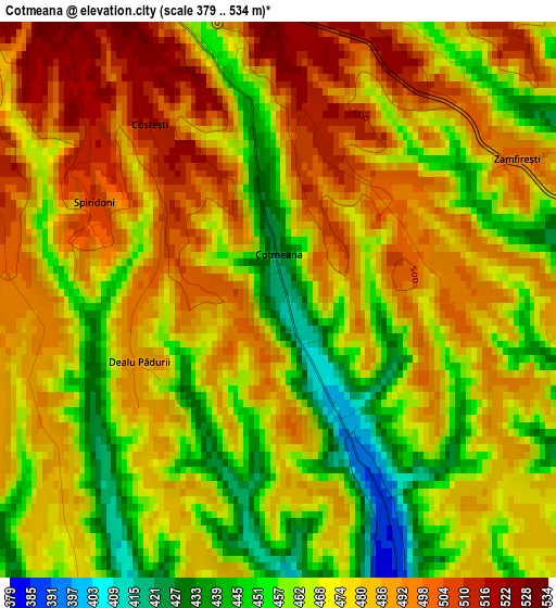
Below is the Elevation map of Cotmeana, which displays elevation range with different colors. Scale of the first map is from 379 to 534 m (1243 to 1752 ft) with average elevation of 475.1 meters (=1559 ft) [note 1]
These maps also provides idea of topography and contour of this city, they are displayed at different zoom levels. More info about maps, scale and edge coordinates you can find below images.
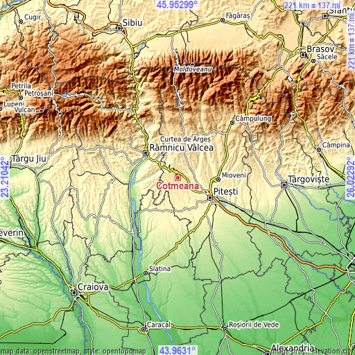
| \ | Map #1 | Topo.Map |
| Scale [m] | 379..534 m | × |
| Scale [ft] | 1243..1752 ft | × |
| Average | 475.1 m = 1559 ft | × |
| Width | 6.91 km = 4.3 mi | 221.3 km = 137.5 mi |
| Height | 6.91 km = 4.3 mi | 221.2 km = 137.4 mi |
| ↑Max Latitude | 44.997754° | 45.95299° |
| Latitude at center | 44.96667° | 44.96667° |
| ↓Min Latitude | 44.935569° | 43.9631° |
| ← Min Longitude | 24.572725° | 23.21042° |
| Longitude center | 24.61667° | 24.61667° |
| →Max Longitude | 24.660615° | 26.02292° |
Nearby cities:
Cities around Cotmeana sort by population:
• Băiculeşti elevation 413 m
12.9 km,  30°
30°
• Merişani 329 m
10 km,  89°
89°
• Băbana 366 m
9.9 km,  138°
138°
• Cocu 413 m
11.4 km,  166°
166°
• Ciofrângeni 367 m
14.5 km,  333°
333°
• Uda 446 m
6.8 km,  215°
215°
• Cuca 438 m
8.1 km,  256°
256°
• Morăreşti 546 m
6.8 km,  324°
324°
• Drăganu-Olteni 378 m
8.7 km,  115°
115°
• Tutana 394 m
8.9 km,  17°
17°
• Gălășești 320 m
13.4 km,  95°
95°
• Poienari 341 m
13.4 km, 329°
Multilingual:
 En español:
Cotmeana elevación 418 m.
 En France:
Cotmeana élévation 418 m.
 Auf Deutsch:
Cotmeana höhe über dem Meeresspiegel ist 418 m.

Sources and notes:
- [note 1] Map square and city borders are not equal. Map elevation data is calculated only from area inside that square.
- [src 1] Elevation data from geonames database provided with same terms of usage.
- [src 2] The elevation map of Cotmeana is generated using elevation data from NASA's 3 arcsec (90m) resolution SRTM data.
- [src 3] Base (background) map © OpenStreetMap contributors tiles are generated by Geofabrik and OpenTopoMap.
Copyright & License:
This Cotmeana Elevation Map is licensed under CC BY-SA. You may reuse any part from this page, if you give a proper credit by linking to this URL:
 More info on terms of use page.