Viişoara elevation
Viişoara (Bihor, Comuna Viişoara), Romania elevation is 207 meters and Viişoara elevation in feet is 679 ft above sea level [src 1]. Viişoara is a seat of a second-order administrative division (feature code) with elevation that is 45 meters (148 ft) smaller than average city elevation in Romania.
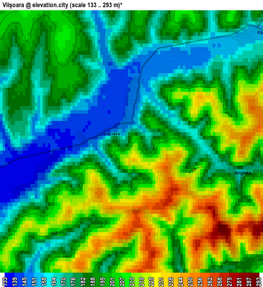
Below is the Elevation map of Viişoara, which displays elevation range with different colors. Scale of the first map is from 133 to 293 m (436 to 961 ft) with average elevation of 192.5 meters (=632 ft) [note 1]
These maps also provides idea of topography and contour of this city, they are displayed at different zoom levels. More info about maps, scale and edge coordinates you can find below images.
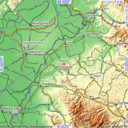
| \ | Map #1 | Topo.Map |
| Scale [m] | 133..293 m | × |
| Scale [ft] | 436..961 ft | × |
| Average | 192.5 m = 632 ft | × |
| Width | 6.62 km = 4.1 mi | 211.7 km = 131.5 mi |
| Height | 6.62 km = 4.1 mi | 211.7 km = 131.5 mi |
| ↑Max Latitude | 47.413077° | 48.3269° |
| Latitude at center | 47.38333° | 47.38333° |
| ↓Min Latitude | 47.353567° | 46.42257° |
| ← Min Longitude | 22.406055° | 21.04375° |
| Longitude center | 22.45° | 22.45° |
| →Max Longitude | 22.493945° | 23.85625° |
Nearby cities:
Cities around Viişoara sort by population:
• Marghita elevation 140 m
9.5 km,  247°
247°
• Balc 166 m
12.8 km,  150°
150°
• Abram 130 m
9 km,  214°
214°
• Sălacea 105 m
13.7 km,  312°
312°
• Cehal 228 m
11.3 km,  90°
90°
• Buduslău 136 m
13.9 km,  277°
277°
• Pir 123 m
11.2 km,  325°
325°
• Petreu 127 m
12.7 km, 246°
• Săuca 159 m
9.6 km,  15°
15°
• Boianu Mare 185 m
6.3 km, 90°
• Cheț 170 m
9.3 km,  295°
295°
• Ciutelec 163 m
14.3 km,  199°
199°
Multilingual:
 En español:
Viişoara elevación 207 m.
 En France:
Viişoara élévation 207 m.
 Auf Deutsch:
Viişoara höhe über dem Meeresspiegel ist 207 m.

Sources and notes:
- [note 1] Map square and city borders are not equal. Map elevation data is calculated only from area inside that square.
- [src 1] Elevation data from geonames database provided with same terms of usage.
- [src 2] The elevation map of Viişoara is generated using elevation data from NASA's 3 arcsec (90m) resolution SRTM data.
- [src 3] Base (background) map © OpenStreetMap contributors tiles are generated by Geofabrik and OpenTopoMap.
Copyright & License:
This Viişoara Elevation Map is licensed under CC BY-SA. You may reuse any part from this page, if you give a proper credit by linking to this URL:
 More info on terms of use page.