Sălacea elevation
Sălacea (Bihor, Comuna Sălacea), Romania elevation is 105 meters and Sălacea elevation in feet is 344 ft above sea level [src 1]. Sălacea is a seat of a second-order administrative division (feature code) with elevation that is 147 meters (482 ft) smaller than average city elevation in Romania.
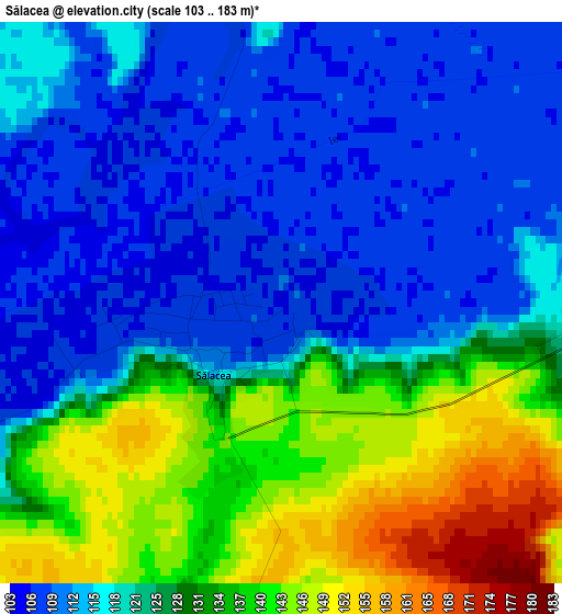
Below is the Elevation map of Sălacea, which displays elevation range with different colors. Scale of the first map is from 103 to 183 m (338 to 600 ft) with average elevation of 124.1 meters (=407 ft) [note 1]
These maps also provides idea of topography and contour of this city, they are displayed at different zoom levels. More info about maps, scale and edge coordinates you can find below images.
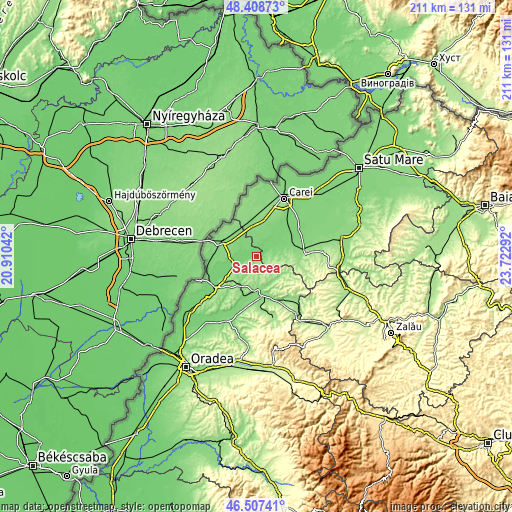
| \ | Map #1 | Topo.Map |
| Scale [m] | 103..183 m | × |
| Scale [ft] | 338..600 ft | × |
| Average | 124.1 m = 407 ft | × |
| Width | 6.61 km = 4.1 mi | 211.4 km = 131.4 mi |
| Height | 6.61 km = 4.1 mi | 211.4 km = 131.4 mi |
| ↑Max Latitude | 47.496369° | 48.40873° |
| Latitude at center | 47.46667° | 47.46667° |
| ↓Min Latitude | 47.436954° | 46.50741° |
| ← Min Longitude | 22.272725° | 20.91042° |
| Longitude center | 22.31667° | 22.31667° |
| →Max Longitude | 22.360615° | 23.72292° |
Nearby cities:
Cities around Sălacea sort by population:
• Marghita elevation 140 m
13 km,  174°
174°
• Pişcolt 127 m
13 km,  354°
354°
• Curtuișeni 129 m
12.3 km,  315°
315°
• Tarcea 105 m
10.2 km,  259°
259°
• Andrid 113 m
6.1 km,  24°
24°
• Buduslău 136 m
8.3 km,  206°
206°
• Pir 123 m
3.8 km,  90°
90°
• Săuca 159 m
12.5 km, 90°
• Cheț 170 m
5.5 km,  162°
162°
• Vășad 123 m
7.3 km, 321°
• Albiș 135 m
10.1 km, 212°
• Galoșpetreu 112 m
7.7 km,  284°
284°
Multilingual:
 En español:
Sălacea elevación 105 m.
 En France:
Sălacea élévation 105 m.


Sources and notes:
- [note 1] Map square and city borders are not equal. Map elevation data is calculated only from area inside that square.
- [src 1] Elevation data from geonames database provided with same terms of usage.
- [src 2] The elevation map of Sălacea is generated using elevation data from NASA's 3 arcsec (90m) resolution SRTM data.
- [src 3] Base (background) map © OpenStreetMap contributors tiles are generated by Geofabrik and OpenTopoMap.
Copyright & License:
This Sălacea Elevation Map is licensed under CC BY-SA. You may reuse any part from this page, if you give a proper credit by linking to this URL:
 More info on terms of use page.