Chore elevation
Chore (San Pedro), Paraguay elevation is 179 meters and Chore elevation in feet is 587 ft above sea level [src 1]. Chore is a seat of a second-order administrative division (feature code) with elevation that is 5 meters (16 ft) bigger than average city elevation in Paraguay.
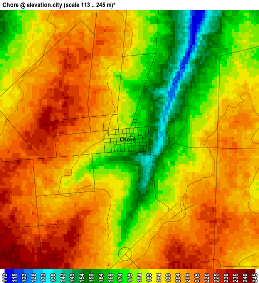
Below is the Elevation map of Chore, which displays elevation range with different colors. Scale of the first map is from 113 to 245 m (371 to 804 ft) with average elevation of 195.8 meters (=642 ft) [note 1]
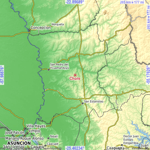
These maps also provides idea of topography and contour of this city, they are displayed at different zoom levels. More info about maps, scale and edge coordinates you can find below images.
| \ | Map #1 | Topo.Map |
| Scale [m] | 113..245 m | × |
| Scale [ft] | 371..804 ft | × |
| Average | 195.8 m = 642 ft | × |
| Width | 8.91 km = 5.5 mi | 285.3 km = 177.3 mi |
| Height | 8.91 km = 5.5 mi | 285.3 km = 177.3 mi |
| ↑Max Latitude | -24.145966° | -22.89689° |
| Latitude at center | -24.18606° | -24.18606° |
| ↓Min Latitude | -24.226141° | -25.46234° |
| ← Min Longitude | -56.626455° | -57.98876° |
| Longitude center | -56.58251° | -56.58251° |
| →Max Longitude | -56.538565° | -55.17626° |
Nearby cities:
Cities around Chore sort by population:
• Lima elevation 137 m
35.2 km,  16°
16°
• San Pedro de Ycuamandiyú 81 m
52.4 km,  282°
282°
• Puerto Rosario 70 m
63.5 km,  243°
243°
• Itacurubí del Rosario 102 m
45.9 km,  212°
212°
• Capiíbary 314 m
88 km,  140°
140°
• General Elizardo Aquino 104 m
43.2 km,  228°
228°
• Antequera 70 m
63.9 km, 280°
• Tacuatí 121 m
81.8 km,  359°
359°
• Guayaybi 284 m
41.5 km,  158°
158°
• Unión 121 m
69.4 km,  174°
174°
• Yataity del Norte 183 m
75.7 km, 161°
• Colonia Nueva Germania 123 m
32.8 km,  338°
338°
Multilingual:
 En español:
Chore elevación 179 m.
 En France:
Chore élévation 179 m.


Sources and notes:
- [note 1] Map square and city borders are not equal. Map elevation data is calculated only from area inside that square.
- [src 1] Elevation data from geonames database provided with same terms of usage.
- [src 2] The elevation map of Chore is generated using elevation data from NASA's 3 arcsec (90m) resolution SRTM data.
- [src 3] Base (background) map © OpenStreetMap contributors tiles are generated by Geofabrik and OpenTopoMap.
Copyright & License:
This Chore Elevation Map is licensed under CC BY-SA. You may reuse any part from this page, if you give a proper credit by linking to this URL:
 More info on terms of use page.