San Pedro de Ycuamandiyú elevation
San Pedro de Ycuamandiyú (San Pedro, San Pedro Del Ykuamandiyu), Paraguay elevation is 81 meters and San Pedro de Ycuamandiyú elevation in feet is 266 ft above sea level [src 1]. San Pedro de Ycuamandiyú is a seat of a first-order administrative division (feature code) with elevation that is 93 meters (305 ft) smaller than average city elevation in Paraguay.
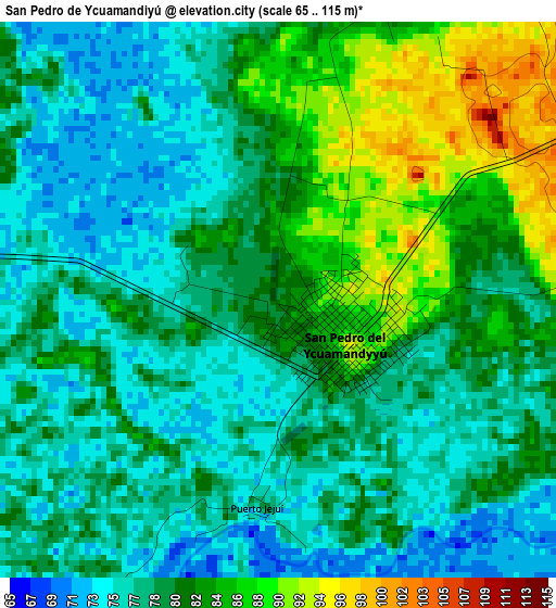
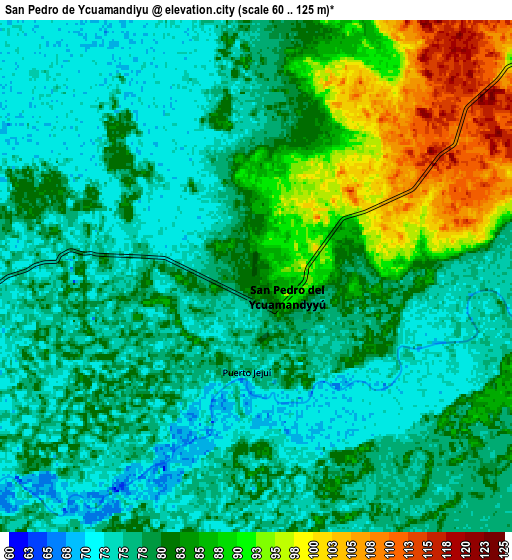
Below is the Elevation map of San Pedro de Ycuamandiyú, which displays elevation range with different colors. Scale of the first map is from 65 to 115 m (213 to 377 ft) with average elevation of 80 meters (=262 ft) [note 1]
These maps also provides idea of topography and contour of this city, they are displayed at different zoom levels. More info about maps, scale and edge coordinates you can find below images.
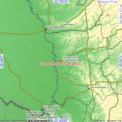
| \ | Map #1 | Map #2 | Topo.Map |
| Scale [m] | 65..115 m | 60..125 m | × |
| Scale [ft] | 213..377 ft | 197..410 ft | × |
| Average | 80 m = 262 ft | 80.3 m = 263 ft | × |
| Width | 8.92 km = 5.5 mi | 17.84 km = 11.1 mi | 285.5 km = 177.4 mi |
| Height | 8.92 km = 5.5 mi | 17.84 km = 11.1 mi | 285.5 km = 177.4 mi |
| ↑Max Latitude | -24.045214° | -24.005076° | -22.79518° |
| Latitude at center | -24.08534° | -24.08534° | -24.08534° |
| ↓Min Latitude | -24.125453° | -24.165554° | -25.36265° |
| ← Min Longitude | -57.131395° | -57.175341° | -58.4937° |
| Longitude center | -57.08745° | -57.08745° | -57.08745° |
| →Max Longitude | -57.043505° | -56.999559° | -55.6812° |
Nearby cities:
Cities around San Pedro de Ycuamandiyú sort by population:
• Concepción elevation 78 m
83.9 km,  335°
335°
• Horqueta 165 m
82.6 km,  1°
1°
• Lima 137 m
65.5 km,  69°
69°
• Puerto Rosario 70 m
40 km,  188°
188°
• Itacurubí del Rosario 102 m
56.7 km,  151°
151°
• General Elizardo Aquino 104 m
44.2 km, 154°
• Antequera 70 m
11.6 km,  270°
270°
• Tacuatí 121 m
87.3 km,  35°
35°
• Guayaybi 284 m
82.9 km,  126°
126°
• Belén 100 m
71.1 km,  345°
345°
• Colonia Nueva Germania 123 m
43.8 km,  63°
63°
• Chore 179 m
52.4 km,  102°
102°
Multilingual:
 En español:
San Pedro de Ycuamandiyú elevación 81 m.
 En France:
San Pedro de Ycuamandiyú élévation 81 m.
 Auf Deutsch:
San Pedro de Ycuamandiyú höhe über dem Meeresspiegel ist 81 m.
 На русском:
San Pedro de Ycuamandiyú высота над уровнем моря 81 м
Sources and notes:
- [note 1] Map square and city borders are not equal. Map elevation data is calculated only from area inside that square.
- [src 1] Elevation data from geonames database provided with same terms of usage.
- [src 2] The elevation map of San Pedro de Ycuamandiyú is generated using elevation data from NASA's 3 arcsec (90m) resolution SRTM data.
- [src 3] Base (background) map © OpenStreetMap contributors tiles are generated by Geofabrik and OpenTopoMap.
Copyright & License:
This San Pedro de Ycuamandiyú Elevation Map is licensed under CC BY-SA. You may reuse any part from this page, if you give a proper credit by linking to this URL:
 More info on terms of use page.