Tacuatí elevation
Tacuatí (San Pedro), Paraguay elevation is 121 meters and Tacuatí elevation in feet is 397 ft above sea level [src 1]. Tacuatí is a populated place (feature code) with elevation that is 53 meters (174 ft) smaller than average city elevation in Paraguay.
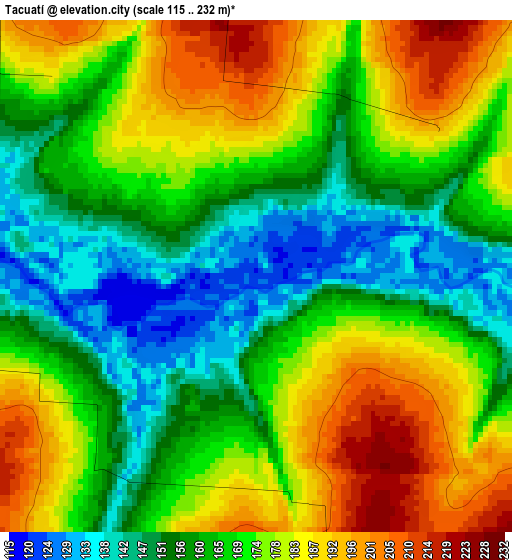
Below is the Elevation map of Tacuatí, which displays elevation range with different colors. Scale of the first map is from 115 to 232 m (377 to 761 ft) with average elevation of 169 meters (=554 ft) [note 1]
These maps also provides idea of topography and contour of this city, they are displayed at different zoom levels. More info about maps, scale and edge coordinates you can find below images.
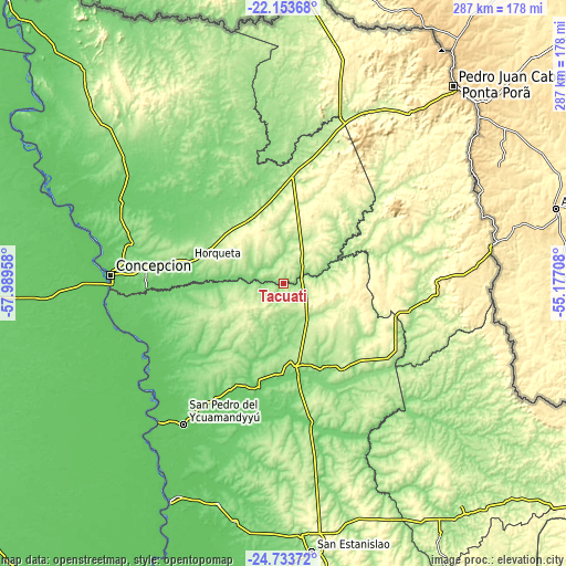
| \ | Map #1 | Topo.Map |
| Scale [m] | 115..232 m | × |
| Scale [ft] | 377..761 ft | × |
| Average | 169 m = 554 ft | × |
| Width | 8.97 km = 5.6 mi | 286.9 km = 178.3 mi |
| Height | 8.97 km = 5.6 mi | 286.9 km = 178.3 mi |
| ↑Max Latitude | -23.409678° | -22.15368° |
| Latitude at center | -23.45° | -23.45° |
| ↓Min Latitude | -23.49031° | -24.73372° |
| ← Min Longitude | -56.627275° | -57.98958° |
| Longitude center | -56.58333° | -56.58333° |
| →Max Longitude | -56.539385° | -55.17708° |
Nearby cities:
Cities around Tacuatí sort by population:
• Concepción elevation 78 m
86.8 km,  273°
273°
• Horqueta 165 m
50.1 km,  283°
283°
• Lima 137 m
49.3 km,  167°
167°
• San Pedro de Ycuamandiyú 81 m
87.3 km,  215°
215°
• Capitán Bado 514 m
109.1 km,  79°
79°
• General Elizardo Aquino 104 m
115.1 km,  196°
196°
• Ygatimi 197 m
121.4 km,  128°
128°
• Antequera 70 m
94.6 km, 221°
• Guayaybi 284 m
121.4 km, 172°
• Belén 100 m
69.2 km, 268°
• Colonia Nueva Germania 123 m
52.7 km,  193°
193°
• Chore 179 m
81.8 km,  179°
179°
Multilingual:
 En español:
Tacuatí elevación 121 m.
 En France:
Tacuatí élévation 121 m.


Sources and notes:
- [note 1] Map square and city borders are not equal. Map elevation data is calculated only from area inside that square.
- [src 1] Elevation data from geonames database provided with same terms of usage.
- [src 2] The elevation map of Tacuatí is generated using elevation data from NASA's 3 arcsec (90m) resolution SRTM data.
- [src 3] Base (background) map © OpenStreetMap contributors tiles are generated by Geofabrik and OpenTopoMap.
Copyright & License:
This Tacuatí Elevation Map is licensed under CC BY-SA. You may reuse any part from this page, if you give a proper credit by linking to this URL:
 More info on terms of use page.