Unión elevation
Unión (San Pedro, Union), Paraguay elevation is 121 meters and Unión elevation in feet is 397 ft above sea level [src 1]. Unión is a populated place (feature code) with elevation that is 53 meters (174 ft) smaller than average city elevation in Paraguay.
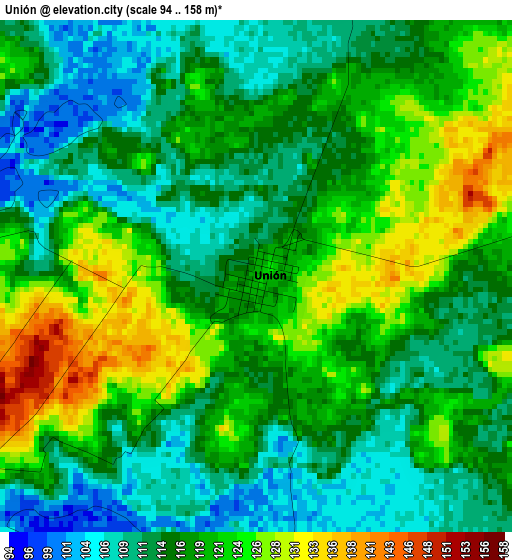
Below is the Elevation map of Unión, which displays elevation range with different colors. Scale of the first map is from 94 to 158 m (308 to 518 ft) with average elevation of 117.3 meters (=385 ft) [note 1]
These maps also provides idea of topography and contour of this city, they are displayed at different zoom levels. More info about maps, scale and edge coordinates you can find below images.
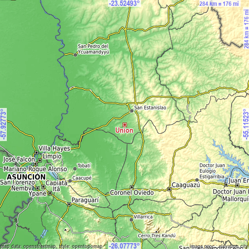
| \ | Map #1 | Topo.Map |
| Scale [m] | 94..158 m | × |
| Scale [ft] | 308..518 ft | × |
| Average | 117.3 m = 385 ft | × |
| Width | 8.87 km = 5.5 mi | 283.8 km = 176.3 mi |
| Height | 8.87 km = 5.5 mi | 283.9 km = 176.4 mi |
| ↑Max Latitude | -24.768004° | -23.52493° |
| Latitude at center | -24.8079° | -24.8079° |
| ↓Min Latitude | -24.847784° | -26.07773° |
| ← Min Longitude | -56.565425° | -57.92773° |
| Longitude center | -56.52148° | -56.52148° |
| →Max Longitude | -56.477535° | -55.11523° |
Nearby cities:
Cities around Unión sort by population:
• Itacurubí del Rosario elevation 102 m
43 km,  314°
314°
• Capiíbary 314 m
49.3 km,  88°
88°
• General Elizardo Aquino 104 m
55.7 km,  316°
316°
• Carayaó 111 m
45 km,  164°
164°
• Arroyos y Esteros 90 m
64.4 km,  244°
244°
• Guayaybi 284 m
31.8 km,  16°
16°
• Yhú 320 m
66.5 km,  114°
114°
• Cecilio Baez 204 m
40.5 km,  136°
136°
• San Joaquín 346 m
54.1 km,  116°
116°
• Caraguatay 96 m
56.9 km,  212°
212°
• Mbutuý 174 m
28.4 km,  130°
130°
• Yataity del Norte 183 m
17.5 km,  99°
99°
Multilingual:
 En español:
Unión elevación 121 m.
 En France:
Unión élévation 121 m.


Sources and notes:
- [note 1] Map square and city borders are not equal. Map elevation data is calculated only from area inside that square.
- [src 1] Elevation data from geonames database provided with same terms of usage.
- [src 2] The elevation map of Unión is generated using elevation data from NASA's 3 arcsec (90m) resolution SRTM data.
- [src 3] Base (background) map © OpenStreetMap contributors tiles are generated by Geofabrik and OpenTopoMap.
Copyright & License:
This Unión Elevation Map is licensed under CC BY-SA. You may reuse any part from this page, if you give a proper credit by linking to this URL:
 More info on terms of use page.