Boticas elevation
Boticas (Vila Real), Portugal elevation is 491 meters and Boticas elevation in feet is 1611 ft above sea level [src 1]. Boticas is a seat of a second-order administrative division (feature code) with elevation that is 323 meters (1060 ft) bigger than average city elevation in Portugal.
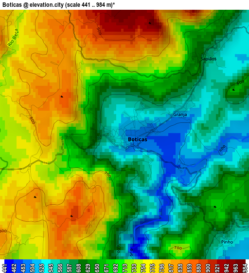
Below is the Elevation map of Boticas, which displays elevation range with different colors. Scale of the first map is from 441 to 984 m (1447 to 3228 ft) with average elevation of 684.3 meters (=2245 ft) [note 1]
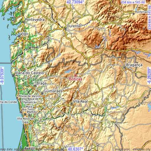
These maps also provides idea of topography and contour of this city, they are displayed at different zoom levels. More info about maps, scale and edge coordinates you can find below images.
| \ | Map #1 | Map #2 | Topo.Map |
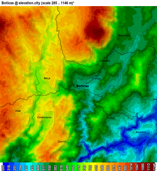
| Scale [m] | 441..984 m | 285..1146 m | × |
| Scale [ft] | 1447..3228 ft | 935..3760 ft | × |
| Average | 684.3 m = 2245 ft | 699.8 m = 2296 ft | × |
| Width | 7.3 km = 4.5 mi | 14.6 km = 9.1 mi | 233.5 km = 145.1 mi |
| Height | 7.3 km = 4.5 mi | 14.6 km = 9.1 mi | 233.5 km = 145.1 mi |
| ↑Max Latitude | 41.722198° | 41.75499° | 42.73094° |
| Latitude at center | 41.68939° | 41.68939° | 41.68939° |
| ↓Min Latitude | 41.656565° | 41.623723° | 40.6307° |
| ← Min Longitude | -7.713085° | -7.757031° | -9.07539° |
| Longitude center | -7.66914° | -7.66914° | -7.66914° |
| →Max Longitude | -7.625195° | -7.581249° | -6.26289° |
Nearby cities:
Cities around Boticas sort by population:
• Chaves elevation 362 m
17.6 km,  71°
71°
• Cabeceiras de Basto 295 m
33 km,  233°
233°
• Mondim de Basto 201 m
39 km,  217°
217°
• Refojos de Basto 313 m
33.4 km, 234°
• Valpaços 432 m
31.1 km,  107°
107°
• Sobreira 422 m
21.5 km,  211°
211°
• Santa Cruz 399 m
18.4 km,  64°
64°
• Vieira do Minho 396 m
39.8 km,  260°
260°
• Murça 488 m
36.2 km,  150°
150°
• Ribeira de Pena 432 m
21.7 km, 210°
• Vila Pouca de Aguiar 734 m
21.1 km,  174°
174°
• Montalegre 996 m
18 km,  326°
326°
Multilingual:
 En español:
Boticas elevación 491 m.
 En France:
Boticas élévation 491 m.


Sources and notes:
- [note 1] Map square and city borders are not equal. Map elevation data is calculated only from area inside that square.
- [src 1] Elevation data from geonames database provided with same terms of usage.
- [src 2] The elevation map of Boticas is generated using elevation data from NASA's 3 arcsec (90m) resolution SRTM data.
- [src 3] Base (background) map © OpenStreetMap contributors tiles are generated by Geofabrik and OpenTopoMap.
Copyright & License:
This Boticas Elevation Map is licensed under CC BY-SA. You may reuse any part from this page, if you give a proper credit by linking to this URL:
 More info on terms of use page.