Valpaços elevation
Valpaços (Vila Real), Portugal elevation is 432 meters and Valpaços elevation in feet is 1417 ft above sea level [src 1]. Valpaços is a seat of a second-order administrative division (feature code) with elevation that is 264 meters (866 ft) bigger than average city elevation in Portugal.
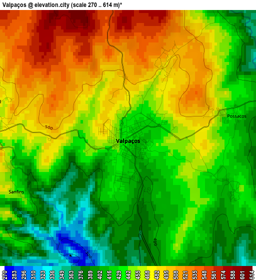
Below is the Elevation map of Valpaços, which displays elevation range with different colors. Scale of the first map is from 270 to 614 m (886 to 2014 ft) with average elevation of 448.1 meters (=1470 ft) [note 1]
These maps also provides idea of topography and contour of this city, they are displayed at different zoom levels. More info about maps, scale and edge coordinates you can find below images.
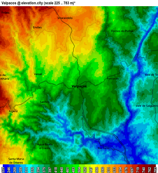
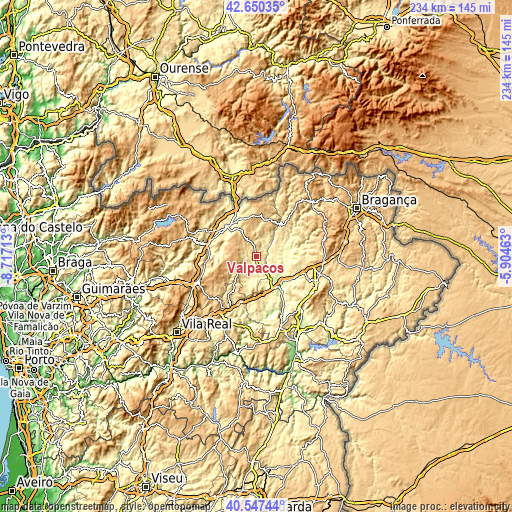
| \ | Map #1 | Map #2 | Topo.Map |
| Scale [m] | 270..614 m | 225..783 m | × |
| Scale [ft] | 886..2014 ft | 738..2569 ft | × |
| Average | 448.1 m = 1470 ft | 451 m = 1480 ft | × |
| Width | 7.31 km = 4.5 mi | 14.61 km = 9.1 mi | 233.8 km = 145.3 mi |
| Height | 7.31 km = 4.5 mi | 14.61 km = 9.1 mi | 233.8 km = 145.3 mi |
| ↑Max Latitude | 41.64031° | 41.673143° | 42.65035° |
| Latitude at center | 41.60746° | 41.60746° | 41.60746° |
| ↓Min Latitude | 41.574593° | 41.54171° | 40.54744° |
| ← Min Longitude | -7.354825° | -7.398771° | -8.71713° |
| Longitude center | -7.31088° | -7.31088° | -7.31088° |
| →Max Longitude | -7.266935° | -7.222989° | -5.90463° |
Nearby cities:
Cities around Valpaços sort by population:
• Chaves elevation 362 m
19.7 km,  318°
318°
• Mirandela 215 m
16.9 km,  142°
142°
• Alijó 578 m
39.3 km,  200°
200°
• Vinhais 706 m
35.8 km,  45°
45°
• Macedo de Cavaleiros 558 m
30.1 km,  104°
104°
• Carrazeda de Anciães 766 m
40.6 km,  179°
179°
• Boticas 491 m
31.1 km,  287°
287°
• Santa Cruz 399 m
21.4 km, 322°
• Belver 762 m
40.2 km, 175°
• Vila Flor 560 m
35.7 km,  158°
158°
• Vila Pouca de Aguiar 734 m
30.2 km,  246°
246°
• Murça 488 m
25.4 km,  208°
208°
Multilingual:
 En español:
Valpaços elevación 432 m.
 En France:
Valpaços élévation 432 m.
 Auf Deutsch:
Valpaços höhe über dem Meeresspiegel ist 432 m.

Sources and notes:
- [note 1] Map square and city borders are not equal. Map elevation data is calculated only from area inside that square.
- [src 1] Elevation data from geonames database provided with same terms of usage.
- [src 2] The elevation map of Valpaços is generated using elevation data from NASA's 3 arcsec (90m) resolution SRTM data.
- [src 3] Base (background) map © OpenStreetMap contributors tiles are generated by Geofabrik and OpenTopoMap.
Copyright & License:
This Valpaços Elevation Map is licensed under CC BY-SA. You may reuse any part from this page, if you give a proper credit by linking to this URL:
 More info on terms of use page.