Alijó elevation
Alijó (Vila Real), Portugal elevation is 578 meters and Alijó elevation in feet is 1896 ft above sea level [src 1]. Alijó is a populated place (feature code) with elevation that is 410 meters (1345 ft) bigger than average city elevation in Portugal.
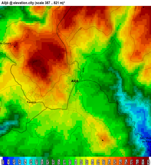
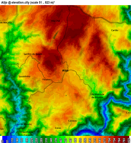
Below is the Elevation map of Alijó, which displays elevation range with different colors. Scale of the first map is from 387 to 821 m (1270 to 2694 ft) with average elevation of 628.1 meters (=2061 ft) [note 1]
These maps also provides idea of topography and contour of this city, they are displayed at different zoom levels. More info about maps, scale and edge coordinates you can find below images.
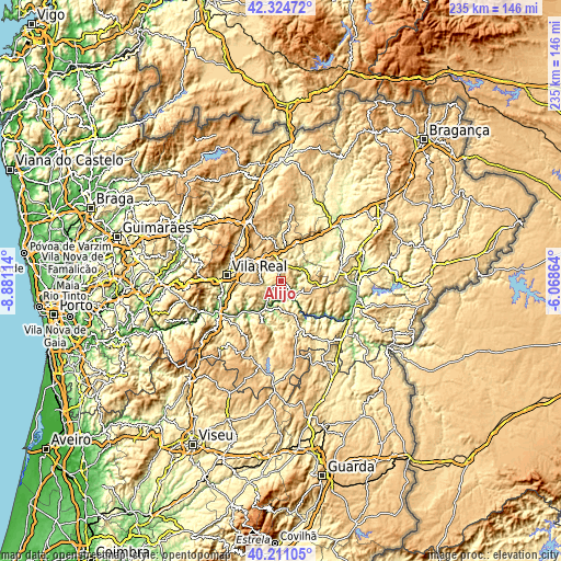
| \ | Map #1 | Map #2 | Topo.Map |
| Scale [m] | 387..821 m | 51..823 m | × |
| Scale [ft] | 1270..2694 ft | 167..2700 ft | × |
| Average | 628.1 m = 2061 ft | 524.9 m = 1722 ft | × |
| Width | 7.34 km = 4.6 mi | 14.69 km = 9.1 mi | 235 km = 146 mi |
| Height | 7.34 km = 4.6 mi | 14.69 km = 9.1 mi | 235 km = 146 mi |
| ↑Max Latitude | 41.309458° | 41.342459° | 42.32472° |
| Latitude at center | 41.27644° | 41.27644° | 41.27644° |
| ↓Min Latitude | 41.243405° | 41.210354° | 40.21105° |
| ← Min Longitude | -7.518835° | -7.562781° | -8.88114° |
| Longitude center | -7.47489° | -7.47489° | -7.47489° |
| →Max Longitude | -7.430945° | -7.386999° | -6.06864° |
Nearby cities:
Cities around Alijó sort by population:
• Custoias elevation 569 m
23 km,  145°
145°
• Vila Real 462 m
22.7 km,  276°
276°
• São João da Pesqueira 609 m
15.4 km,  157°
157°
• Carrazeda de Anciães 766 m
14.5 km,  105°
105°
• Sabrosa 584 m
8.5 km,  262°
262°
• Tabuaço 542 m
19.4 km,  203°
203°
• Vilela 712 m
12.2 km,  242°
242°
• Ervedosa do Douro 573 m
12.3 km,  179°
179°
• Belver 762 m
16.9 km,  101°
101°
• Favaios 642 m
2.6 km,  251°
251°
• Armamar 576 m
26.1 km,  223°
223°
• Murça 488 m
14.5 km,  6°
6°
Multilingual:
 En español:
Alijó elevación 578 m.
 En France:
Alijó élévation 578 m.


Sources and notes:
- [note 1] Map square and city borders are not equal. Map elevation data is calculated only from area inside that square.
- [src 1] Elevation data from geonames database provided with same terms of usage.
- [src 2] The elevation map of Alijó is generated using elevation data from NASA's 3 arcsec (90m) resolution SRTM data.
- [src 3] Base (background) map © OpenStreetMap contributors tiles are generated by Geofabrik and OpenTopoMap.
Copyright & License:
This Alijó Elevation Map is licensed under CC BY-SA. You may reuse any part from this page, if you give a proper credit by linking to this URL:
 More info on terms of use page.