Custoias elevation
Custoias (Guarda, Vila Nova de Foz Côa), Portugal elevation is 569 meters and Custoias elevation in feet is 1867 ft above sea level [src 1]. Custoias is a populated place (feature code) with elevation that is 401 meters (1316 ft) bigger than average city elevation in Portugal.
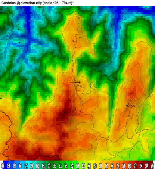
Below is the Elevation map of Custoias, which displays elevation range with different colors. Scale of the first map is from 106 to 794 m (348 to 2605 ft) with average elevation of 459.1 meters (=1506 ft) [note 1]
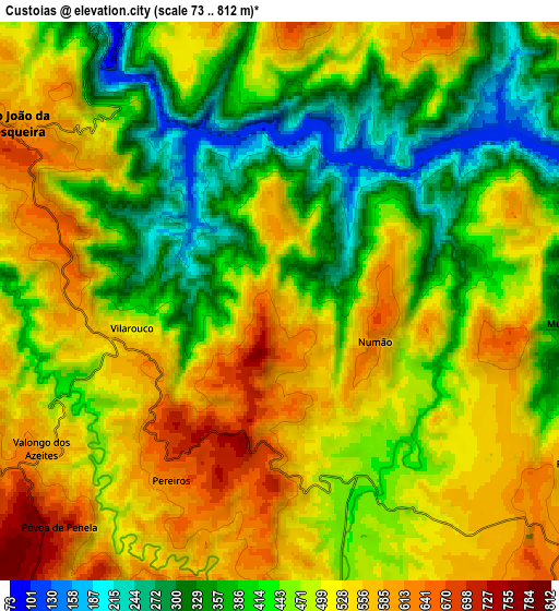
These maps also provides idea of topography and contour of this city, they are displayed at different zoom levels. More info about maps, scale and edge coordinates you can find below images.
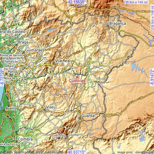
| \ | Map #1 | Map #2 | Topo.Map |
| Scale [m] | 106..794 m | 73..812 m | × |
| Scale [ft] | 348..2605 ft | 240..2664 ft | × |
| Average | 459.1 m = 1506 ft | 469.1 m = 1539 ft | × |
| Width | 7.36 km = 4.6 mi | 14.73 km = 9.2 mi | 235.6 km = 146.4 mi |
| Height | 7.36 km = 4.6 mi | 14.73 km = 9.2 mi | 235.6 km = 146.4 mi |
| ↑Max Latitude | 41.138405° | 41.171492° | 42.15635° |
| Latitude at center | 41.1053° | 41.1053° | 41.1053° |
| ↓Min Latitude | 41.072179° | 41.039041° | 40.03715° |
| ← Min Longitude | -7.364915° | -7.408861° | -8.72722° |
| Longitude center | -7.32097° | -7.32097° | -7.32097° |
| →Max Longitude | -7.277025° | -7.233079° | -5.91472° |
Nearby cities:
Cities around Custoias sort by population:
• Alijó elevation 578 m
23 km,  325°
325°
• Torre de Moncorvo 397 m
23.7 km,  71°
71°
• São João da Pesqueira 609 m
8.5 km,  304°
304°
• Vila Nova de Foz Côa 385 m
15.3 km,  99°
99°
• Carrazeda de Anciães 766 m
15.3 km,  4°
4°
• Tabuaço 542 m
20.7 km,  273°
273°
• Penedono 918 m
14.3 km,  205°
205°
• Mêda 713 m
16.2 km,  162°
162°
• Ervedosa do Douro 573 m
14.4 km, 298°
• Belver 762 m
16.2 km,  13°
13°
• Favaios 642 m
23.8 km,  319°
319°
• Vila Flor 560 m
26.6 km,  31°
31°
Multilingual:
 En español:
Custoias elevación 569 m.
 En France:
Custoias élévation 569 m.
 Auf Deutsch:
Custoias höhe über dem Meeresspiegel ist 569 m.

Sources and notes:
- [note 1] Map square and city borders are not equal. Map elevation data is calculated only from area inside that square.
- [src 1] Elevation data from geonames database provided with same terms of usage.
- [src 2] The elevation map of Custoias is generated using elevation data from NASA's 3 arcsec (90m) resolution SRTM data.
- [src 3] Base (background) map © OpenStreetMap contributors tiles are generated by Geofabrik and OpenTopoMap.
Copyright & License:
This Custoias Elevation Map is licensed under CC BY-SA. You may reuse any part from this page, if you give a proper credit by linking to this URL:
 More info on terms of use page.