Vila Flor elevation
Vila Flor (Bragança), Portugal elevation is 560 meters and Vila Flor elevation in feet is 1837 ft above sea level [src 1]. Vila Flor is a seat of a second-order administrative division (feature code) with elevation that is 392 meters (1286 ft) bigger than average city elevation in Portugal.
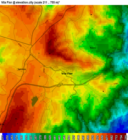
Below is the Elevation map of Vila Flor, which displays elevation range with different colors. Scale of the first map is from 211 to 755 m (692 to 2477 ft) with average elevation of 538.9 meters (=1768 ft) [note 1]
These maps also provides idea of topography and contour of this city, they are displayed at different zoom levels. More info about maps, scale and edge coordinates you can find below images.
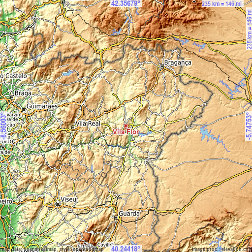
| \ | Map #1 | Topo.Map |
| Scale [m] | 211..755 m | × |
| Scale [ft] | 692..2477 ft | × |
| Average | 538.9 m = 1768 ft | × |
| Width | 7.34 km = 4.6 mi | 234.9 km = 146 mi |
| Height | 7.34 km = 4.6 mi | 234.9 km = 146 mi |
| ↑Max Latitude | 41.342042° | 42.35679° |
| Latitude at center | 41.30904° | 41.30904° |
| ↓Min Latitude | 41.276022° | 40.24418° |
| ← Min Longitude | -7.197725° | -8.56003° |
| Longitude center | -7.15378° | -7.15378° |
| →Max Longitude | -7.109835° | -5.74753° |
Nearby cities:
Cities around Vila Flor sort by population:
• Custoias elevation 569 m
26.6 km,  211°
211°
• Mirandela 215 m
20 km,  352°
352°
• Alijó 578 m
27.1 km,  262°
262°
• Torre de Moncorvo 397 m
17.1 km,  150°
150°
• São João da Pesqueira 609 m
27.6 km,  229°
229°
• Vila Nova de Foz Côa 385 m
25.3 km,  177°
177°
• Macedo de Cavaleiros 558 m
30.1 km,  32°
32°
• Carrazeda de Anciães 766 m
14.8 km,  240°
240°
• Belver 762 m
12.3 km, 235°
• Favaios 642 m
29.7 km, 261°
• Murça 488 m
27.3 km,  293°
293°
• Alfândega da Fé 543 m
16.5 km,  76°
76°
Multilingual:
 En español:
Vila Flor elevación 560 m.
 En France:
Vila Flor élévation 560 m.
 Auf Deutsch:
Vila Flor höhe über dem Meeresspiegel ist 560 m.

Sources and notes:
- [note 1] Map square and city borders are not equal. Map elevation data is calculated only from area inside that square.
- [src 1] Elevation data from geonames database provided with same terms of usage.
- [src 2] The elevation map of Vila Flor is generated using elevation data from NASA's 3 arcsec (90m) resolution SRTM data.
- [src 3] Base (background) map © OpenStreetMap contributors tiles are generated by Geofabrik and OpenTopoMap.
Copyright & License:
This Vila Flor Elevation Map is licensed under CC BY-SA. You may reuse any part from this page, if you give a proper credit by linking to this URL:
 More info on terms of use page.