Mondim de Basto elevation
Mondim de Basto (Vila Real), Portugal elevation is 201 meters and Mondim de Basto elevation in feet is 659 ft above sea level [src 1]. Mondim de Basto is a seat of a second-order administrative division (feature code) with elevation that is 33 meters (108 ft) bigger than average city elevation in Portugal.
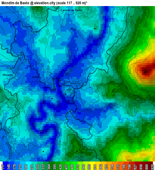
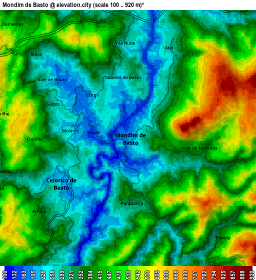
Below is the Elevation map of Mondim de Basto, which displays elevation range with different colors. Scale of the first map is from 117 to 920 m (384 to 3018 ft) with average elevation of 282 meters (=925 ft) [note 1]
These maps also provides idea of topography and contour of this city, they are displayed at different zoom levels. More info about maps, scale and edge coordinates you can find below images.
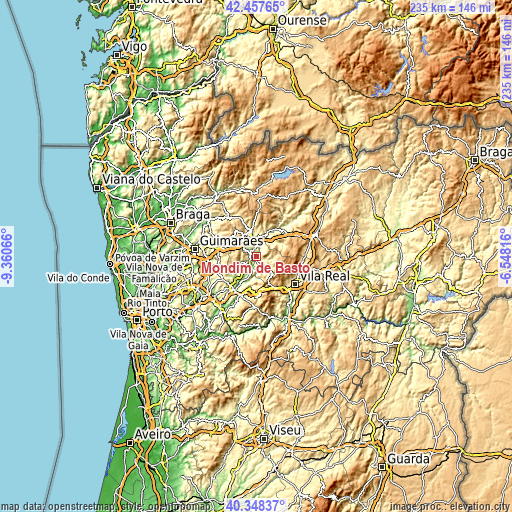
| \ | Map #1 | Map #2 | Topo.Map |
| Scale [m] | 117..920 m | 100..920 m | × |
| Scale [ft] | 384..3018 ft | 328..3018 ft | × |
| Average | 282 m = 925 ft | 390.5 m = 1281 ft | × |
| Width | 7.33 km = 4.6 mi | 14.66 km = 9.1 mi | 234.5 km = 145.7 mi |
| Height | 7.33 km = 4.6 mi | 14.66 km = 9.1 mi | 234.5 km = 145.7 mi |
| ↑Max Latitude | 41.44452° | 41.477453° | 42.45765° |
| Latitude at center | 41.41157° | 41.41157° | 41.41157° |
| ↓Min Latitude | 41.378604° | 41.345621° | 40.34837° |
| ← Min Longitude | -7.998355° | -8.042301° | -9.36066° |
| Longitude center | -7.95441° | -7.95441° | -7.95441° |
| →Max Longitude | -7.910465° | -7.866519° | -6.54816° |
Nearby cities:
Cities around Mondim de Basto sort by population:
• Felgueiras elevation 348 m
20.6 km,  256°
256°
• Vila Real 462 m
21.5 km,  125°
125°
• Fafe 338 m
18.7 km,  283°
283°
• Cabeceiras de Basto 295 m
11.8 km,  345°
345°
• Margaride 308 m
21.1 km, 255°
• Amarante 96 m
18.8 km,  214°
214°
• Refojos de Basto 313 m
11.8 km,  343°
343°
• Telões 262 m
17.2 km,  229°
229°
• Figueiró 332 m
21.8 km, 234°
• Sobreira 422 m
17.8 km,  45°
45°
• Ribeira de Pena 432 m
17.6 km, 46°
• Celorico de Basto 222 m
4.7 km,  235°
235°
Multilingual:
 En español:
Mondim de Basto elevación 201 m.
 En France:
Mondim de Basto élévation 201 m.
 Auf Deutsch:
Mondim de Basto höhe über dem Meeresspiegel ist 201 m.

Sources and notes:
- [note 1] Map square and city borders are not equal. Map elevation data is calculated only from area inside that square.
- [src 1] Elevation data from geonames database provided with same terms of usage.
- [src 2] The elevation map of Mondim de Basto is generated using elevation data from NASA's 3 arcsec (90m) resolution SRTM data.
- [src 3] Base (background) map © OpenStreetMap contributors tiles are generated by Geofabrik and OpenTopoMap.
Copyright & License:
This Mondim de Basto Elevation Map is licensed under CC BY-SA. You may reuse any part from this page, if you give a proper credit by linking to this URL:
 More info on terms of use page.