Caranguejeira elevation
Caranguejeira (Leiria), Portugal elevation is 129 meters and Caranguejeira elevation in feet is 423 ft above sea level [src 1]. Caranguejeira is a populated place (feature code) with elevation that is 39 meters (128 ft) smaller than average city elevation in Portugal.
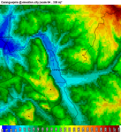
Below is the Elevation map of Caranguejeira, which displays elevation range with different colors. Scale of the first map is from 64 to 338 m (210 to 1109 ft) with average elevation of 169.4 meters (=556 ft) [note 1]
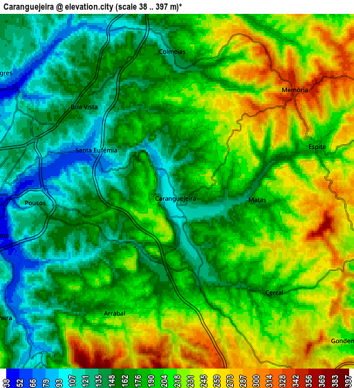
These maps also provides idea of topography and contour of this city, they are displayed at different zoom levels. More info about maps, scale and edge coordinates you can find below images.
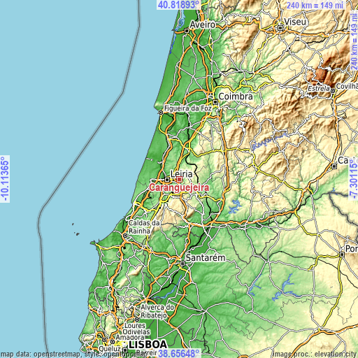
| \ | Map #1 | Map #2 | Topo.Map |
| Scale [m] | 64..338 m | 38..397 m | × |
| Scale [ft] | 210..1109 ft | 125..1302 ft | × |
| Average | 169.4 m = 556 ft | 189.1 m = 620 ft | × |
| Width | 7.51 km = 4.7 mi | 15.03 km = 9.3 mi | 240.4 km = 149.4 mi |
| Height | 7.51 km = 4.7 mi | 15.03 km = 9.3 mi | 240.4 km = 149.4 mi |
| ↑Max Latitude | 39.779971° | 39.813735° | 40.81893° |
| Latitude at center | 39.74619° | 39.74619° | 39.74619° |
| ↓Min Latitude | 39.712393° | 39.678579° | 38.65648° |
| ← Min Longitude | -8.751345° | -8.795291° | -10.11365° |
| Longitude center | -8.7074° | -8.7074° | -8.7074° |
| →Max Longitude | -8.663455° | -8.619509° | -7.30115° |
Nearby cities:
Cities around Caranguejeira sort by population:
• Leiria elevation 33 m
8.5 km,  268°
268°
• Marinha Grande 91 m
19.2 km, 270°
• Pombal 69 m
20.1 km,  19°
19°
• Ourém 315 m
15.3 km,  139°
139°
• Fátima 358 m
14.7 km,  161°
161°
• Maceira 164 m
17.2 km,  248°
248°
• Batalha 71 m
13.9 km,  226°
226°
• Porto de Mós 136 m
18.6 km,  210°
210°
• Monte Real 20 m
17.8 km,  311°
311°
• Amor 25 m
14.5 km,  296°
296°
• Santa Catarina da Serra 338 m
7.6 km,  166°
166°
• Souto da Carpalhosa 51 m
15.8 km,  316°
316°
Multilingual:
 En español:
Caranguejeira elevación 129 m.
 En France:
Caranguejeira élévation 129 m.
 Auf Deutsch:
Caranguejeira höhe über dem Meeresspiegel ist 129 m.

Sources and notes:
- [note 1] Map square and city borders are not equal. Map elevation data is calculated only from area inside that square.
- [src 1] Elevation data from geonames database provided with same terms of usage.
- [src 2] The elevation map of Caranguejeira is generated using elevation data from NASA's 3 arcsec (90m) resolution SRTM data.
- [src 3] Base (background) map © OpenStreetMap contributors tiles are generated by Geofabrik and OpenTopoMap.
Copyright & License:
This Caranguejeira Elevation Map is licensed under CC BY-SA. You may reuse any part from this page, if you give a proper credit by linking to this URL:
 More info on terms of use page.