Souto da Carpalhosa elevation
Souto da Carpalhosa (Leiria), Portugal elevation is 51 meters and Souto da Carpalhosa elevation in feet is 167 ft above sea level [src 1]. Souto da Carpalhosa is a populated place (feature code) with elevation that is 117 meters (384 ft) smaller than average city elevation in Portugal.
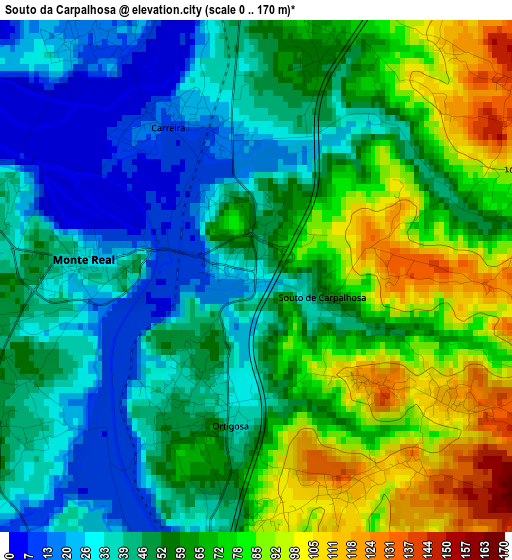
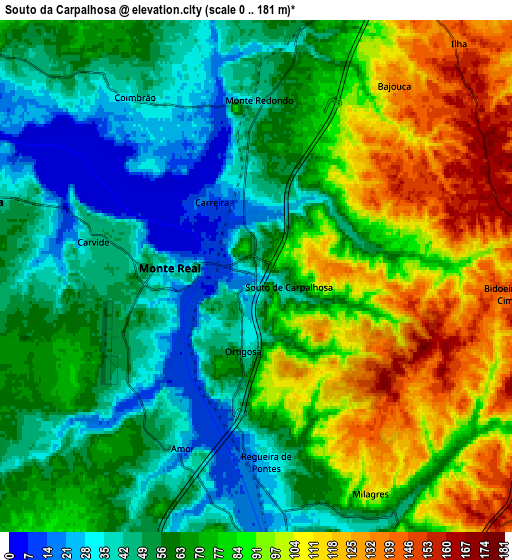
Below is the Elevation map of Souto da Carpalhosa, which displays elevation range with different colors. Scale of the first map is from 0 to 170 m (0 to 558 ft) with average elevation of 56.5 meters (=185 ft) [note 1]
These maps also provides idea of topography and contour of this city, they are displayed at different zoom levels. More info about maps, scale and edge coordinates you can find below images.
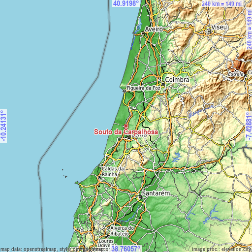
| \ | Map #1 | Map #2 | Topo.Map |
| Scale [m] | 0..170 m | 0..181 m | × |
| Scale [ft] | 0..558 ft | 0..594 ft | × |
| Average | 56.5 m = 185 ft | 71.4 m = 234 ft | × |
| Width | 7.5 km = 4.7 mi | 15.01 km = 9.3 mi | 240.1 km = 149.2 mi |
| Height | 7.5 km = 4.7 mi | 15.01 km = 9.3 mi | 240.1 km = 149.2 mi |
| ↑Max Latitude | 39.8824° | 39.916114° | 40.9198° |
| Latitude at center | 39.84867° | 39.84867° | 39.84867° |
| ↓Min Latitude | 39.814923° | 39.78116° | 38.76057° |
| ← Min Longitude | -8.879005° | -8.922951° | -10.24131° |
| Longitude center | -8.83506° | -8.83506° | -8.83506° |
| →Max Longitude | -8.791115° | -8.747169° | -7.42881° |
Nearby cities:
Cities around Souto da Carpalhosa sort by population:
• Leiria elevation 33 m
11.9 km,  168°
168°
• Marinha Grande 91 m
14 km,  216°
216°
• Pombal 69 m
19.2 km,  66°
66°
• Maceira 164 m
18.5 km,  195°
195°
• Batalha 71 m
21 km,  177°
177°
• Vieira de Leiria 50 m
8.6 km,  285°
285°
• Monte Real 20 m
2.5 km,  278°
278°
• Caranguejeira 129 m
15.8 km,  136°
136°
• Louriçal 29 m
19.2 km,  25°
25°
• Amor 25 m
5.4 km, 203°
• Monte Redondo 47 m
5.6 km,  2°
2°
• Santa Catarina da Serra 338 m
22.7 km,  146°
146°
Multilingual:
 En español:
Souto da Carpalhosa elevación 51 m.
 En France:
Souto da Carpalhosa élévation 51 m.
 Auf Deutsch:
Souto da Carpalhosa höhe über dem Meeresspiegel ist 51 m.
 На русском:
Souto da Carpalhosa высота над уровнем моря 51 м
Sources and notes:
- [note 1] Map square and city borders are not equal. Map elevation data is calculated only from area inside that square.
- [src 1] Elevation data from geonames database provided with same terms of usage.
- [src 2] The elevation map of Souto da Carpalhosa is generated using elevation data from NASA's 3 arcsec (90m) resolution SRTM data.
- [src 3] Base (background) map © OpenStreetMap contributors tiles are generated by Geofabrik and OpenTopoMap.
Copyright & License:
This Souto da Carpalhosa Elevation Map is licensed under CC BY-SA. You may reuse any part from this page, if you give a proper credit by linking to this URL:
 More info on terms of use page.