Castelo Branco elevation
Castelo Branco, Portugal elevation is 409 meters and Castelo Branco elevation in feet is 1342 ft above sea level [src 1]. Castelo Branco is a seat of a first-order administrative division (feature code) with elevation that is 241 meters (791 ft) bigger than average city elevation in Portugal.
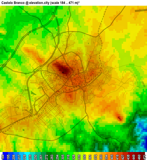
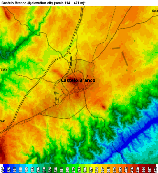
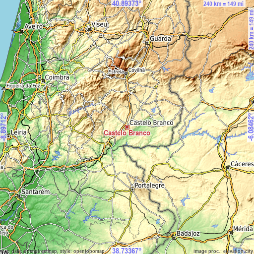
Below is the Elevation map of Castelo Branco, which displays elevation range with different colors. Scale of the first map is from 184 to 471 m (604 to 1545 ft) with average elevation of 349.4 meters (=1146 ft) [note 1]
These maps also provides idea of topography and contour of this city, they are displayed at different zoom levels. More info about maps, scale and edge coordinates you can find below images.
| \ | Map #1 | Map #2 | Topo.Map |
| Scale [m] | 184..471 m | 114..471 m | × |
| Scale [ft] | 604..1545 ft | 374..1545 ft | × |
| Average | 349.4 m = 1146 ft | 313.8 m = 1030 ft | × |
| Width | 7.51 km = 4.7 mi | 15.01 km = 9.3 mi | 240.2 km = 149.3 mi |
| Height | 7.51 km = 4.7 mi | 15.01 km = 9.3 mi | 240.2 km = 149.3 mi |
| ↑Max Latitude | 39.855933° | 39.88966° | 40.89373° |
| Latitude at center | 39.82219° | 39.82219° | 39.82219° |
| ↓Min Latitude | 39.78843° | 39.754654° | 38.73367° |
| ← Min Longitude | -7.534815° | -7.578761° | -8.89712° |
| Longitude center | -7.49087° | -7.49087° | -7.49087° |
| →Max Longitude | -7.446925° | -7.402979° | -6.08462° |
Nearby cities:
Cities around Castelo Branco sort by population:
• Fundão elevation 482 m
35.4 km,  358°
358°
• Nisa 307 m
36.7 km,  201°
201°
• Oleiros 510 m
37.7 km,  286°
286°
• Alcains 362 m
10.9 km,  15°
15°
• Proença-a-Nova 464 m
37.8 km,  258°
258°
• Castelo de Vide 570 m
45.2 km,  176°
176°
• Vila Velha de Ródão 183 m
24.3 km,  220°
220°
• Pampilhosa da Serra 398 m
46.5 km,  302°
302°
• Aldeia de Joanes 471 m
35.3 km, 356°
• Penamacor 561 m
47.3 km,  35°
35°
• Póvoa e Meadas 335 m
34.7 km, 183°
• Idanha-a-Nova 387 m
24.1 km,  62°
62°
Multilingual:
 En español:
Castelo Branco elevación 409 m.
 En France:
Castelo Branco élévation 409 m.
 Auf Deutsch:
Castelo Branco höhe über dem Meeresspiegel ist 409 m.

Sources and notes:
- [note 1] Map square and city borders are not equal. Map elevation data is calculated only from area inside that square.
- [src 1] Elevation data from geonames database provided with same terms of usage.
- [src 2] The elevation map of Castelo Branco is generated using elevation data from NASA's 3 arcsec (90m) resolution SRTM data.
- [src 3] Base (background) map © OpenStreetMap contributors tiles are generated by Geofabrik and OpenTopoMap.
Copyright & License:
This Castelo Branco Elevation Map is licensed under CC BY-SA. You may reuse any part from this page, if you give a proper credit by linking to this URL:
 More info on terms of use page.