Curral das Freiras elevation
Curral das Freiras (Madeira, Câmara de Lobos), Portugal elevation is 435 meters and Curral das Freiras elevation in feet is 1427 ft above sea level [src 1]. Curral das Freiras is a populated place (feature code) with elevation that is 267 meters (876 ft) bigger than average city elevation in Portugal.
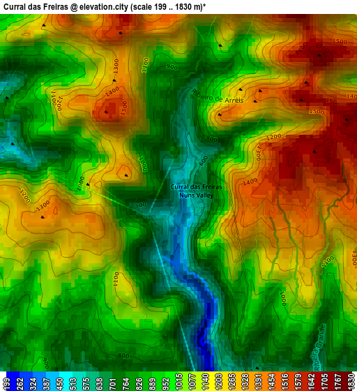
Below is the Elevation map of Curral das Freiras, which displays elevation range with different colors. Scale of the first map is from 199 to 1830 m (653 to 6004 ft) with average elevation of 1046.1 meters (=3432 ft) [note 1]
These maps also provides idea of topography and contour of this city, they are displayed at different zoom levels. More info about maps, scale and edge coordinates you can find below images.
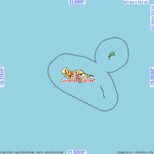
| \ | Map #1 | Topo.Map |
| Scale [m] | 199..1830 m | × |
| Scale [ft] | 653..6004 ft | × |
| Average | 1046.1 m = 3432 ft | × |
| Width | 8.22 km = 5.1 mi | 263.1 km = 163.5 mi |
| Height | 8.22 km = 5.1 mi | 263.1 km = 163.5 mi |
| ↑Max Latitude | 32.757254° | 33.8955° |
| Latitude at center | 32.72029° | 32.72029° |
| ↓Min Latitude | 32.68331° | 31.52939° |
| ← Min Longitude | -17.013875° | -18.37618° |
| Longitude center | -16.96993° | -16.96993° |
| →Max Longitude | -16.925985° | -15.56368° |
Nearby cities:
Cities around Curral das Freiras sort by population:
• Funchal elevation 280 m
7.4 km,  145°
145°
• Câmara de Lobos 252 m
7.8 km,  184°
184°
• São Martinho 193 m
8.9 km,  160°
160°
• São Roque 294 m
7.8 km,  140°
140°
• Santana 492 m
12 km,  42°
42°
• Nossa Senhora do Monte 350 m
8.9 km,  132°
132°
• São Vicente 111 m
10.9 km,  321°
321°
• Ribeira Brava 208 m
10.1 km,  239°
239°
• Campanário 234 m
8.6 km,  225°
225°
• Canhas 364 m
12.4 km,  256°
256°
• São Jorge 73 m
12.6 km,  31°
31°
• Boaventura 123 m
10.9 km,  358°
358°
Multilingual:
 En español:
Curral das Freiras elevación 435 m.
 En France:
Curral das Freiras élévation 435 m.
 Auf Deutsch:
Curral das Freiras höhe über dem Meeresspiegel ist 435 m.
 На русском:
Куррал-даш-Фрейраш высота над уровнем моря 435 м
Sources and notes:
- [note 1] Map square and city borders are not equal. Map elevation data is calculated only from area inside that square.
- [src 1] Elevation data from geonames database provided with same terms of usage.
- [src 2] The elevation map of Curral das Freiras is generated using elevation data from NASA's 3 arcsec (90m) resolution SRTM data.
- [src 3] Base (background) map © OpenStreetMap contributors tiles are generated by Geofabrik and OpenTopoMap.
Copyright & License:
This Curral das Freiras Elevation Map is licensed under CC BY-SA. You may reuse any part from this page, if you give a proper credit by linking to this URL:
 More info on terms of use page.