Campanário elevation
Campanário (Madeira, Ribeira Brava), Portugal elevation is 234 meters and Campanário elevation in feet is 768 ft above sea level [src 1]. Campanário is a populated place (feature code) with elevation that is 66 meters (217 ft) bigger than average city elevation in Portugal.
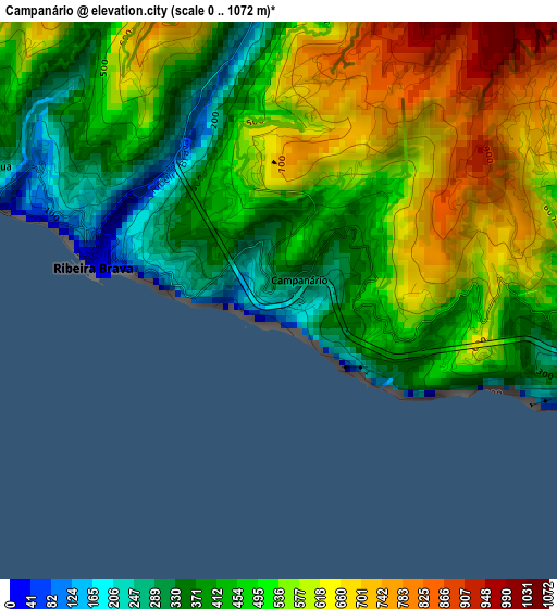
Below is the Elevation map of Campanário, which displays elevation range with different colors. Scale of the first map is from 0 to 1072 m (0 to 3517 ft) with average elevation of 508.5 meters (=1668 ft) [note 1]
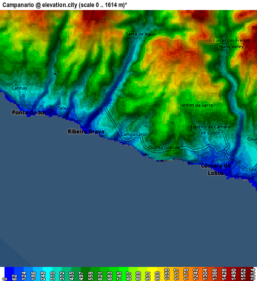
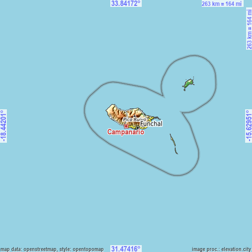
These maps also provides idea of topography and contour of this city, they are displayed at different zoom levels. More info about maps, scale and edge coordinates you can find below images.
| \ | Map #1 | Map #2 | Topo.Map |
| Scale [m] | 0..1072 m | 0..1614 m | × |
| Scale [ft] | 0..3517 ft | 0..5295 ft | × |
| Average | 508.5 m = 1668 ft | 667.2 m = 2189 ft | × |
| Width | 8.23 km = 5.1 mi | 16.45 km = 10.2 mi | 263.2 km = 163.5 mi |
| Height | 8.23 km = 5.1 mi | 16.45 km = 10.2 mi | 263.3 km = 163.6 mi |
| ↑Max Latitude | 32.702767° | 32.739739° | 33.84172° |
| Latitude at center | 32.66578° | 32.66578° | 32.66578° |
| ↓Min Latitude | 32.628778° | 32.59176° | 31.47416° |
| ← Min Longitude | -17.079705° | -17.123651° | -18.44201° |
| Longitude center | -17.03576° | -17.03576° | -17.03576° |
| →Max Longitude | -16.991815° | -16.947869° | -15.62951° |
Nearby cities:
Cities around Campanário sort by population:
• Funchal elevation 280 m
10.3 km,  90°
90°
• Câmara de Lobos 252 m
5.7 km,  107°
107°
• São Martinho 193 m
9.4 km,  104°
104°
• São Roque 294 m
11.1 km, 89°
• Nossa Senhora do Monte 350 m
12.7 km, 89°
• São Vicente 111 m
14.6 km,  357°
357°
• Ribeira Brava 208 m
2.7 km,  291°
291°
• Ponta do Sol 76 m
6.2 km,  284°
284°
• Canhas 364 m
6.7 km,  298°
298°
• Arco da Calheta 236 m
12 km, 297°
• Curral das Freiras 435 m
8.6 km,  45°
45°
• Calheta 120 m
14.9 km, 292°
Multilingual:
 En español:
Campanário elevación 234 m.
 En France:
Campanário élévation 234 m.
 Auf Deutsch:
Campanário höhe über dem Meeresspiegel ist 234 m.

Sources and notes:
- [note 1] Map square and city borders are not equal. Map elevation data is calculated only from area inside that square.
- [src 1] Elevation data from geonames database provided with same terms of usage.
- [src 2] The elevation map of Campanário is generated using elevation data from NASA's 3 arcsec (90m) resolution SRTM data.
- [src 3] Base (background) map © OpenStreetMap contributors tiles are generated by Geofabrik and OpenTopoMap.
Copyright & License:
This Campanário Elevation Map is licensed under CC BY-SA. You may reuse any part from this page, if you give a proper credit by linking to this URL:
 More info on terms of use page.