Abū Dīs elevation
Abū Dīs (West Bank, Al Quds), Palestinian Territory elevation is 641 meters and Abū Dīs elevation in feet is 2103 ft above sea level [src 1]. Abū Dīs is a populated place (feature code) with elevation that is 174 meters (571 ft) bigger than average city elevation in Palestinian Territory.
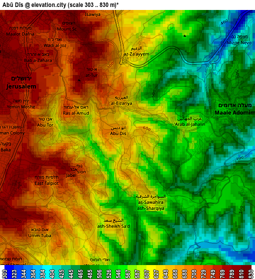
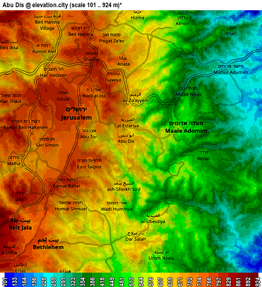
Below is the Elevation map of Abū Dīs, which displays elevation range with different colors. Scale of the first map is from 303 to 830 m (994 to 2723 ft) with average elevation of 603.6 meters (=1980 ft) [note 1]
These maps also provides idea of topography and contour of this city, they are displayed at different zoom levels. More info about maps, scale and edge coordinates you can find below images.
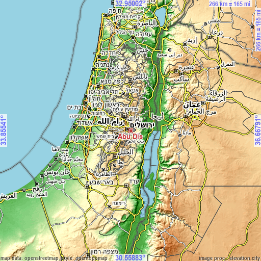
| \ | Map #1 | Map #2 | Topo.Map |
| Scale [m] | 303..830 m | 101..924 m | × |
| Scale [ft] | 994..2723 ft | 331..3031 ft | × |
| Average | 603.6 m = 1980 ft | 564.4 m = 1852 ft | × |
| Width | 8.31 km = 5.2 mi | 16.62 km = 10.3 mi | 265.9 km = 165.2 mi |
| Height | 8.31 km = 5.2 mi | 16.62 km = 10.3 mi | 265.9 km = 165.2 mi |
| ↑Max Latitude | 31.799507° | 31.836848° | 32.95002° |
| Latitude at center | 31.76215° | 31.76215° | 31.76215° |
| ↓Min Latitude | 31.724778° | 31.687392° | 30.55883° |
| ← Min Longitude | 35.217715° | 35.173769° | 33.85541° |
| Longitude center | 35.26166° | 35.26166° | 35.26166° |
| →Max Longitude | 35.305605° | 35.349551° | 36.66791° |
Nearby cities:
Cities around Abū Dīs sort by population:
• East Jerusalem elevation 759 m
3.5 km,  311°
311°
• Old City 738 m
3.1 km,  301°
301°
• Bethlehem 775 m
8.4 km,  220°
220°
• Al ‘Ayzarīyah 566 m
1.2 km,  36°
36°
• Bayt Sāḩūr 609 m
7.6 km,  206°
206°
• ‘Anātā 714 m
5.2 km,  357°
357°
• Al ‘Ubaydīyah 508 m
5.7 km,  151°
151°
• Ḩizmā 601 m
7.9 km,  1°
1°
• Az Za‘ayyim 656 m
3 km,  6°
6°
• Ash Shaykh Sa‘d 642 m
2.8 km,  188°
188°
• Khallat Ḩamāmah 757 m
7.9 km,  235°
235°
• Khallat an Nu‘mān 621 m
5.3 km,  200°
200°
Multilingual:
 En español:
Abū Dīs elevación 641 m.
 En France:
Abū Dīs élévation 641 m.


Sources and notes:
- [note 1] Map square and city borders are not equal. Map elevation data is calculated only from area inside that square.
- [src 1] Elevation data from geonames database provided with same terms of usage.
- [src 2] The elevation map of Abū Dīs is generated using elevation data from NASA's 3 arcsec (90m) resolution SRTM data.
- [src 3] Base (background) map © OpenStreetMap contributors tiles are generated by Geofabrik and OpenTopoMap.
Copyright & License:
This Abū Dīs Elevation Map is licensed under CC BY-SA. You may reuse any part from this page, if you give a proper credit by linking to this URL:
 More info on terms of use page.