‘Aşīrah ash Shamālīyah elevation
‘Aşīrah ash Shamālīyah (West Bank, Nablus), Palestinian Territory elevation is 638 meters and ‘Aşīrah ash Shamālīyah elevation in feet is 2093 ft above sea level [src 1]. ‘Aşīrah ash Shamālīyah is a populated place (feature code) with elevation that is 171 meters (561 ft) bigger than average city elevation in Palestinian Territory.
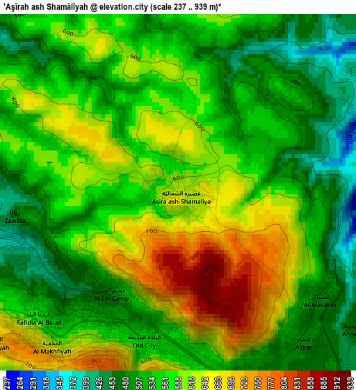
Below is the Elevation map of ‘Aşīrah ash Shamālīyah, which displays elevation range with different colors. Scale of the first map is from 237 to 939 m (778 to 3081 ft) with average elevation of 568.9 meters (=1866 ft) [note 1]
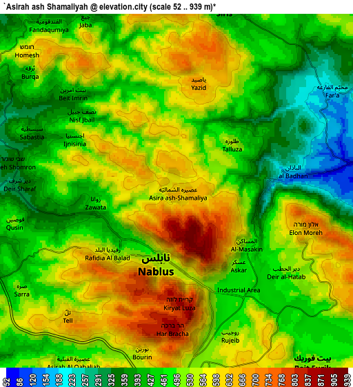
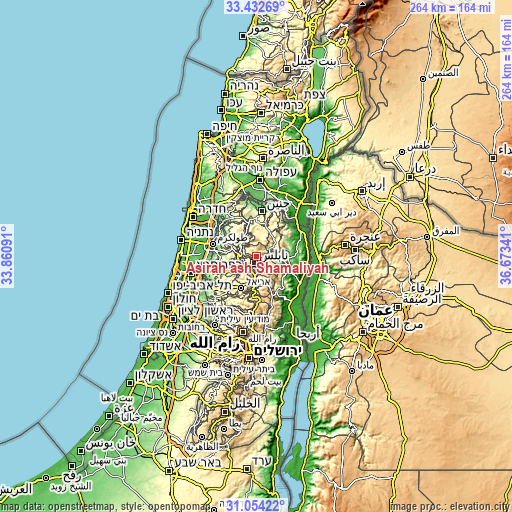
These maps also provides idea of topography and contour of this city, they are displayed at different zoom levels. More info about maps, scale and edge coordinates you can find below images.
| \ | Map #1 | Map #2 | Topo.Map |
| Scale [m] | 237..939 m | 52..939 m | × |
| Scale [ft] | 778..3081 ft | 171..3081 ft | × |
| Average | 568.9 m = 1866 ft | 506.3 m = 1661 ft | × |
| Width | 8.26 km = 5.1 mi | 16.53 km = 10.3 mi | 264.5 km = 164.4 mi |
| Height | 8.26 km = 5.1 mi | 16.53 km = 10.3 mi | 264.5 km = 164.4 mi |
| ↑Max Latitude | 32.288398° | 32.32554° | 33.43269° |
| Latitude at center | 32.25124° | 32.25124° | 32.25124° |
| ↓Min Latitude | 32.214067° | 32.176879° | 31.05422° |
| ← Min Longitude | 35.223215° | 35.179269° | 33.86091° |
| Longitude center | 35.26716° | 35.26716° | 35.26716° |
| →Max Longitude | 35.311105° | 35.355051° | 36.67341° |
Nearby cities:
Cities around ‘Aşīrah ash Shamālīyah sort by population:
• Nablus elevation 569 m
3.6 km,  199°
199°
• Balāţah 494 m
4.7 km,  158°
158°
• Bayt Ībā 363 m
5.6 km,  253°
253°
• ‘Azmūţ 473 m
5.1 km,  128°
128°
• Ţallūzah 543 m
3.4 km,  50°
50°
• Al Bādhān 104 m
6.2 km,  82°
82°
• Kafr Qallīl 531 m
6.6 km,  167°
167°
• Yāşīd 690 m
5.2 km,  10°
10°
• Dayr al Ḩaţab 509 m
6.3 km, 126°
• Zawātā 467 m
3.9 km,  261°
261°
• An Nāqūrah 445 m
6.4 km,  283°
283°
• Bayt Wazan 534 m
5.3 km, 245°
Multilingual:
 En español:
‘Aşīrah ash Shamālīyah elevación 638 m.
 En France:
‘Aşīrah ash Shamālīyah élévation 638 m.
 Auf Deutsch:
‘Aşīrah ash Shamālīyah höhe über dem Meeresspiegel ist 638 m.
 На русском:
‘Aşīrah ash Shamālīyah высота над уровнем моря 638 м
Sources and notes:
- [note 1] Map square and city borders are not equal. Map elevation data is calculated only from area inside that square.
- [src 1] Elevation data from geonames database provided with same terms of usage.
- [src 2] The elevation map of ‘Aşīrah ash Shamālīyah is generated using elevation data from NASA's 3 arcsec (90m) resolution SRTM data.
- [src 3] Base (background) map © OpenStreetMap contributors tiles are generated by Geofabrik and OpenTopoMap.
Copyright & License:
This ‘Aşīrah ash Shamālīyah Elevation Map is licensed under CC BY-SA. You may reuse any part from this page, if you give a proper credit by linking to this URL:
 More info on terms of use page.