Zawātā elevation
Zawātā (West Bank, Nablus), Palestinian Territory elevation is 467 meters and Zawātā elevation in feet is 1532 ft above sea level [src 1]. Zawātā is a populated place (feature code) with elevation that is 0 meters (0 ft) bigger than average city elevation in Palestinian Territory.
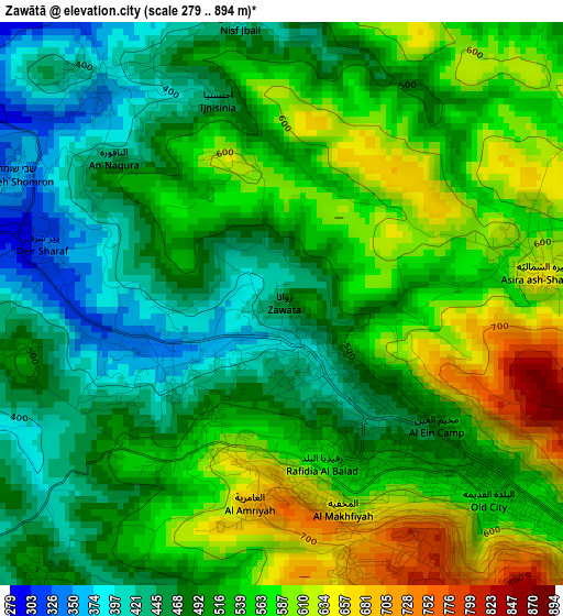
Below is the Elevation map of Zawātā, which displays elevation range with different colors. Scale of the first map is from 279 to 894 m (915 to 2933 ft) with average elevation of 525 meters (=1722 ft) [note 1]
These maps also provides idea of topography and contour of this city, they are displayed at different zoom levels. More info about maps, scale and edge coordinates you can find below images.
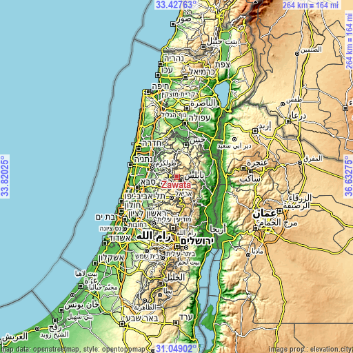
| \ | Map #1 | Topo.Map |
| Scale [m] | 279..894 m | × |
| Scale [ft] | 915..2933 ft | × |
| Average | 525 m = 1722 ft | × |
| Width | 8.27 km = 5.1 mi | 264.5 km = 164.4 mi |
| Height | 8.27 km = 5.1 mi | 264.5 km = 164.4 mi |
| ↑Max Latitude | 32.28327° | 33.42763° |
| Latitude at center | 32.24611° | 32.24611° |
| ↓Min Latitude | 32.208935° | 31.04902° |
| ← Min Longitude | 35.182555° | 33.82025° |
| Longitude center | 35.2265° | 35.2265° |
| →Max Longitude | 35.270445° | 36.63275° |
Nearby cities:
Cities around Zawātā sort by population:
• Nablus elevation 569 m
3.8 km,  136°
136°
• ‘Aşīrah ash Shamālīyah 638 m
3.9 km,  81°
81°
• Till 610 m
5.2 km,  194°
194°
• Bayt Ībā 363 m
1.9 km,  237°
237°
• Sabasţīyah 369 m
4.2 km,  321°
321°
• Şarrah 502 m
5.2 km,  219°
219°
• Bayt Imrīn 442 m
5.3 km,  349°
349°
• Dayr Sharaf 332 m
3.6 km,  282°
282°
• Jīt 502 m
6.3 km, 235°
• Qūşīn 502 m
4.2 km,  258°
258°
• An Nāqūrah 445 m
3.2 km,  311°
311°
• Bayt Wazan 534 m
2 km,  211°
211°
Multilingual:
 En español:
Zawātā elevación 467 m.
 En France:
Zawātā élévation 467 m.


Sources and notes:
- [note 1] Map square and city borders are not equal. Map elevation data is calculated only from area inside that square.
- [src 1] Elevation data from geonames database provided with same terms of usage.
- [src 2] The elevation map of Zawātā is generated using elevation data from NASA's 3 arcsec (90m) resolution SRTM data.
- [src 3] Base (background) map © OpenStreetMap contributors tiles are generated by Geofabrik and OpenTopoMap.
Copyright & License:
This Zawātā Elevation Map is licensed under CC BY-SA. You may reuse any part from this page, if you give a proper credit by linking to this URL:
 More info on terms of use page.