Bardalah elevation
Bardalah (West Bank, Tubas), Palestinian Territory elevation is -56 meters and Bardalah elevation in feet is -184 ft above sea level [src 1]. Bardalah is a populated place (feature code) with elevation that is 523 meters (1716 ft) smaller than average city elevation in Palestinian Territory.
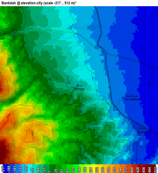
Below is the Elevation map of Bardalah, which displays elevation range with different colors. Scale of the first map is from -217 to 512 m (-712 to 1680 ft) with average elevation of -20.7 meters (=-68 ft) [note 1]
These maps also provides idea of topography and contour of this city, they are displayed at different zoom levels. More info about maps, scale and edge coordinates you can find below images.
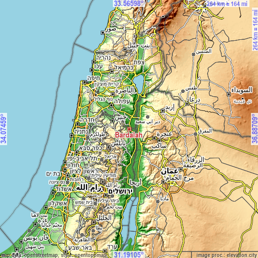
| \ | Map #1 | Topo.Map |
| Scale [m] | -217..512 m | × |
| Scale [ft] | -712..1680 ft | × |
| Average | -20.7 m = -68 ft | × |
| Width | 8.25 km = 5.1 mi | 264.1 km = 164.1 mi |
| Height | 8.25 km = 5.1 mi | 264.1 km = 164.1 mi |
| ↑Max Latitude | 32.423422° | 33.56598° |
| Latitude at center | 32.38632° | 32.38632° |
| ↓Min Latitude | 32.349203° | 31.19105° |
| ← Min Longitude | 35.436895° | 34.07459° |
| Longitude center | 35.48084° | 35.48084° |
| →Max Longitude | 35.524785° | 36.88709° |
Nearby cities:
Cities around Bardalah sort by population:
• Ţūbās elevation 375 m
12.7 km,  235°
235°
• Ţammūn 356 m
14.6 km,  218°
218°
• Dayr Abū Ḑa‘īf 217 m
13.6 km,  304°
304°
• Az Zabābidah 346 m
14.7 km,  270°
270°
• Faqqū‘ah 429 m
13.7 km,  327°
327°
• Rābā 494 m
9.2 km, 270°
• Jalbūn 312 m
10.2 km,  322°
322°
• Tayāsīr 292 m
9.5 km, 237°
• Al Mughayyir 312 m
9.9 km,  293°
293°
• Jalqamūs 383 m
11.7 km, 291°
• Bayt Qād 192 m
14.9 km,  308°
308°
• ‘Ayn al Bayḑā -171 m
2.7 km,  104°
104°
Multilingual:
 En español:
Bardalah elevación -56 m.
 En France:
Bardalah élévation -56 m.
 Auf Deutsch:
Bardalah höhe über dem Meeresspiegel ist -56 m.

Sources and notes:
- [note 1] Map square and city borders are not equal. Map elevation data is calculated only from area inside that square.
- [src 1] Elevation data from geonames database provided with same terms of usage.
- [src 2] The elevation map of Bardalah is generated using elevation data from NASA's 3 arcsec (90m) resolution SRTM data.
- [src 3] Base (background) map © OpenStreetMap contributors tiles are generated by Geofabrik and OpenTopoMap.
Copyright & License:
This Bardalah Elevation Map is licensed under CC BY-SA. You may reuse any part from this page, if you give a proper credit by linking to this URL:
 More info on terms of use page.