Idhnā elevation
Idhnā (West Bank, Al Khalil), Palestinian Territory elevation is 471 meters and Idhnā elevation in feet is 1545 ft above sea level [src 1]. Idhnā is a populated place (feature code) with elevation that is 4 meters (13 ft) bigger than average city elevation in Palestinian Territory.
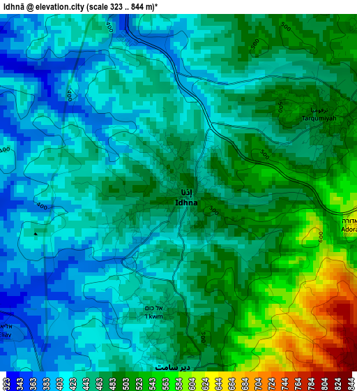
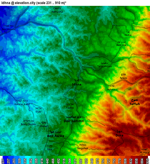
Below is the Elevation map of Idhnā, which displays elevation range with different colors. Scale of the first map is from 323 to 844 m (1060 to 2769 ft) with average elevation of 462.3 meters (=1517 ft) [note 1]
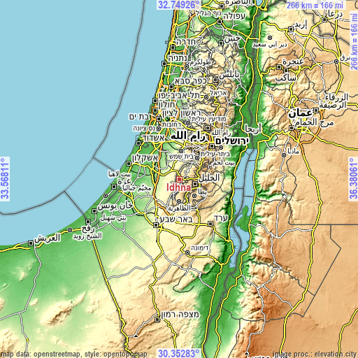
These maps also provides idea of topography and contour of this city, they are displayed at different zoom levels. More info about maps, scale and edge coordinates you can find below images.
| \ | Map #1 | Map #2 | Topo.Map |
| Scale [m] | 323..844 m | 231..910 m | × |
| Scale [ft] | 1060..2769 ft | 758..2986 ft | × |
| Average | 462.3 m = 1517 ft | 499.1 m = 1637 ft | × |
| Width | 8.33 km = 5.2 mi | 16.65 km = 10.3 mi | 266.5 km = 165.6 mi |
| Height | 8.33 km = 5.2 mi | 16.65 km = 10.3 mi | 266.5 km = 165.6 mi |
| ↑Max Latitude | 31.596178° | 31.633602° | 32.74926° |
| Latitude at center | 31.55874° | 31.55874° | 31.55874° |
| ↓Min Latitude | 31.521287° | 31.483818° | 30.35283° |
| ← Min Longitude | 34.930415° | 34.886469° | 33.56811° |
| Longitude center | 34.97436° | 34.97436° | 34.97436° |
| →Max Longitude | 35.018305° | 35.062251° | 36.38061° |
Nearby cities:
Cities around Idhnā sort by population:
• Dūrā elevation 871 m
7.7 km,  137°
137°
• Tarqūmyā 510 m
4 km,  62°
62°
• Taffūḩ 806 m
7.5 km,  107°
107°
• Bayt Ūlā 563 m
6.7 km,  51°
51°
• Bayt ‘Awwā 448 m
6 km,  203°
203°
• Khārās 558 m
8.9 km, 45°
• Dayr Sāmit 445 m
4.2 km,  179°
179°
• Bayt Kāḩil 859 m
8.7 km,  81°
81°
• Nūbā 534 m
8 km, 45°
• al-Kum 432 m
3.3 km, 203°
• Bayt Maqdum 456 m
2.6 km,  185°
185°
• Al Majd 474 m
8.9 km, 194°
Multilingual:
 En español:
Idhnā elevación 471 m.
 En France:
Idhnā élévation 471 m.


Sources and notes:
- [note 1] Map square and city borders are not equal. Map elevation data is calculated only from area inside that square.
- [src 1] Elevation data from geonames database provided with same terms of usage.
- [src 2] The elevation map of Idhnā is generated using elevation data from NASA's 3 arcsec (90m) resolution SRTM data.
- [src 3] Base (background) map © OpenStreetMap contributors tiles are generated by Geofabrik and OpenTopoMap.
Copyright & License:
This Idhnā Elevation Map is licensed under CC BY-SA. You may reuse any part from this page, if you give a proper credit by linking to this URL:
 More info on terms of use page.