Bayt Kāḩil elevation
Bayt Kāḩil (West Bank), Palestinian Territory elevation is 859 meters and Bayt Kāḩil elevation in feet is 2818 ft above sea level [src 1]. Bayt Kāḩil is a populated place (feature code) with elevation that is 392 meters (1286 ft) bigger than average city elevation in Palestinian Territory.
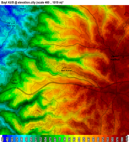
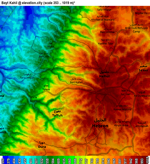
Below is the Elevation map of Bayt Kāḩil, which displays elevation range with different colors. Scale of the first map is from 460 to 1019 m (1509 to 3343 ft) with average elevation of 805.7 meters (=2643 ft) [note 1]
These maps also provides idea of topography and contour of this city, they are displayed at different zoom levels. More info about maps, scale and edge coordinates you can find below images.
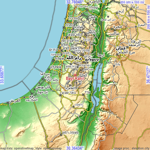
| \ | Map #1 | Map #2 | Topo.Map |
| Scale [m] | 460..1019 m | 353..1019 m | × |
| Scale [ft] | 1509..3343 ft | 1158..3343 ft | × |
| Average | 805.7 m = 2643 ft | 756.6 m = 2482 ft | × |
| Width | 8.33 km = 5.2 mi | 16.65 km = 10.3 mi | 266.4 km = 165.5 mi |
| Height | 8.33 km = 5.2 mi | 16.65 km = 10.3 mi | 266.4 km = 165.5 mi |
| ↑Max Latitude | 31.607544° | 31.644963° | 32.76048° |
| Latitude at center | 31.57011° | 31.57011° | 31.57011° |
| ↓Min Latitude | 31.532661° | 31.495197° | 30.36434° |
| ← Min Longitude | 35.021075° | 34.977129° | 33.65877° |
| Longitude center | 35.06502° | 35.06502° | 35.06502° |
| →Max Longitude | 35.108965° | 35.152911° | 36.47127° |
Nearby cities:
Cities around Bayt Kāḩil sort by population:
• Hebron elevation 903 m
5.3 km,  148°
148°
• Ḩalḩūl 999 m
3.7 km,  71°
71°
• Dūrā 871 m
7.7 km,  206°
206°
• Sa‘īr 919 m
7.2 km,  82°
82°
• Tarqūmyā 510 m
5 km,  276°
276°
• Bayt Ūmmar 942 m
7 km,  32°
32°
• Taffūḩ 806 m
3.8 km,  202°
202°
• Bayt Ūlā 563 m
4.4 km,  310°
310°
• Khārās 558 m
5.4 km,  336°
336°
• Nūbā 534 m
5.2 km,  326°
326°
• Bayt ‘Īnūn 967 m
5.8 km,  102°
102°
• Al Buq‘ah 975 m
8 km,  112°
112°
Multilingual:
 En español:
Bayt Kāḩil elevación 859 m.
 En France:
Bayt Kāḩil élévation 859 m.
 Auf Deutsch:
Bayt Kāḩil höhe über dem Meeresspiegel ist 859 m.

Sources and notes:
- [note 1] Map square and city borders are not equal. Map elevation data is calculated only from area inside that square.
- [src 1] Elevation data from geonames database provided with same terms of usage.
- [src 2] The elevation map of Bayt Kāḩil is generated using elevation data from NASA's 3 arcsec (90m) resolution SRTM data.
- [src 3] Base (background) map © OpenStreetMap contributors tiles are generated by Geofabrik and OpenTopoMap.
Copyright & License:
This Bayt Kāḩil Elevation Map is licensed under CC BY-SA. You may reuse any part from this page, if you give a proper credit by linking to this URL:
 More info on terms of use page.